Data:HydroLAKES
HydroLAKES dataset information page
Short Description
 |
| HydroLAKES global lake database |
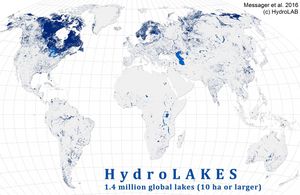
Statement: HydroLAKES is a database aiming to provide the shoreline polygons of all global lakes with a surface area of at least 10 ha.
Abstract: The HydroLAKES database was designed as a digital map repository to include all lakes with a surface area of at least 10 ha. Version 1 comprises the shoreline polygons of 1,427,688 individual lakes. HydroLAKES aims to be as comprehensive and consistent as possible at a global scale and contains both freshwater and saline lakes, including the Caspian Sea, as well as human-made reservoirs and regulated lakes. The HydroLAKES database was created by compiling, correcting, and unifying several near-global and regional datasets, foremost the SRTM Water Body Data (SWBD; Slater et al., 2006) for regions from 56˚S to 60˚N, and CanVec (Natural Resources Canada, 2013) for most North American lakes. Map generalization methods were applied and some polygon outlines were smoothed during the mapping process to ensure spatial consistency of the data. The resulting map scale is estimated to be between 1:100,000 and 1:250,000 for most lakes globally, with some coarser ones at 1:1 million.
Data format
| Data type: | Hydrography |
| Data origin: | Measured |
| Data format: | Shapefile |
| Other format: | |
| Data resolution: | various |
| Datum: | WGS 1984 |
Data Coverage
Spatial data coverage: Global
Temporal data coverage: Time snap shot
Time period covered: ~2000
Availability
Download data: http://www.hydrosheds.org/page/hydrolakes
Data source: http://www.hydrosheds.org/page/hydrolakes
References
- Messager, M.L., Lehner, B., Grill, G., Nedeva, I., Schmitt, O. (2016): Estimating the volume and age of water stored in global lakes using a geo-statistical approach. Nature Communications: 13603. doi: 10.1038/ncomms13603
