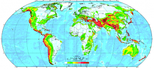
Data:GSHAP
GSHAP dataset information page
Short Description
 |
| Global Seismic Hazard Map |
Statement: Global Seismic Hazard Assessment Program
Abstract: The Global Seismic Hazard Assessment Program (GSHAP) was launched in 1992 by the International Lithosphere Program (ILP) with the support of the International Council of Scientific Unions (ICSU), and endorsed as a demonstration program in the framework of the United Nations International Decade for Natural Disaster Reduction (UN/IDNDR).
In order to mitigate the risk associated to the recurrence of earthquakes, the GSHAP promotes a regionally coordinated, homogeneous approach to seismic hazard evaluation; the ultimate benefits are improved national and regional assessments of seismic hazards, to be used by national decision makers and engineers for land use planning and improved building design and construction.
Data format
| Data type: | Surface properties |
| Data origin: | Measured |
| Data format: | ASCII |
| Other format: | ps |
| Data resolution: | |
| Datum: |
Data Coverage
Spatial data coverage: global
Temporal data coverage: Time averaged
Time period covered: --
Availability
Download data: http://www.seismo.ethz.ch/static/GSHAP/
Data source: http://www.seismo.ethz.ch/static/GSHAP/
References
- D. Giardini, G. Grünthal, K. M. Shedlock, P. Zhang, 1999. The GSHAP Global Seismic Hazard Map. Annals of Geophysics, 42, 1225-1230
