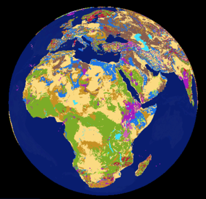
Data:GLiM
GLiM dataset information page
Short Description
 |
| The Global Lithological Map |
Statement: Global Lithological Map
Abstract: Lithology describes the geochemical, mineralogical, and physical properties of rocks. It plays a key role in many processes at the Earth surface, especially the fluxes of matter to soils, ecosystems, rivers, and oceans. The Lithological map of the World is based on the Global Lithological Map database v1.1 (GLiM, Hartmann and Moosdorf, 2012). GLiM represents the rock types of the emerged surface of the Earth using 1,235,400 polygons assembled from 92 regional geological maps, translated into lithological units using additional literature. According to the GLiM, the total surface of continents and islands is covered by 64 % sediments (a third of which is carbonates), 13% metamorphics, 7% plutonics, and 6% volcanics, and 10% are covered by water or ice. The high resolution of the GLiM allows observation of regional lithological distributions which often vary from the global average. The GLiM enables regional analysis of Earth surface processes at global scales. A coarse gridded version of the GLiM is available at the PANGEA Database (http://dx.doi.org/10.1594/PANGAEA.788537), the original GIS data are downloadable using this link (https://www.dropbox.com/s/9vuowtebp9f1iud/LiMW_GIS%202015.gdb.zip?dl=0).
Data format
| Data type: | Surface properties |
| Data origin: | Measured |
| Data format: | |
| Other format: | GDB |
| Data resolution: | 1:3,750,000 |
| Datum: |
Data Coverage
Spatial data coverage: Global
Temporal data coverage: Time snap shot
Time period covered: --
Availability
Download data: http://dx.doi.org/10.1594/PANGAEA.788537
Data source: https://www.dropbox.com/s/9vuowtebp9f1iud/LiMW GIS%202015.gdb.zip?dl=0
References
- Hartmann, J., Moosdorf, N., 2012. The new global lithological map database GLiM: A representation of rock properties at the Earth surface. Geochemistry, Geophysics, Geosystems, 13. DOI: 10.1029/2012GC004370
- https://www.clisap.de/fileadmin/B-Research/IA/IA5/LITHOMAP/dev/lithomap.html
