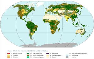
Data:GLC-SHARE
GLC-SHARE dataset information page
Short Description
 |
| A representation of the GLC-SHARE Land Cover Database |
Statement: Global Land Cover-SHARE (GLC-SHARE) provides access to an assembled product of global land cover.
Abstract: The basic concept adopted to develop this database is to integrate the best land cover data available, from local to global, into one single database using international standards; this task requires the harmonization among different layers and legends to create a consistent product. Here are criteria and steps for the harmonization:
- absorb, overcome and minimize the thematic and spatio-temporal differences between individual databases;
- create an efficient and practical mechanism to harmonize various datasets using the land cover elements;
- use data fusion techniques to overcome some of the harmonization issues;
identify agreement/disagreement between a limited number of global dataset at pixel level;
- create land cover database;
- validate land cover database;
- develop a fully automated “procedure” to update the database when new datasets may become available.
Data format
| Data type: | Land Cover |
| Data origin: | Measured |
| Data format: | GeoTIFF |
| Other format: | |
| Data resolution: | 30 arc seconds |
| Datum: | WGS1984 |
Data Coverage
Spatial data coverage: Globaly
Temporal data coverage: Time snap shot
Time period covered: Sometime between early 2000s and 2014.
Availability
Download data: http://www.glcn.org/databases/lc glcshare downloads en.jsp
Data source: http://www.glcn.org/databases/lc glcshare en.jsp
References
- GLC-SHARE, Global Land Cover SHARE. Database Beta-Release Version 1.0 - 2014, by John Latham, Renato Cumani, Ilaria Rosati and Mario Bloise. FAO document.
