Data:Coastal DEMs
Coastal DEMs dataset information page
Short Description
 |
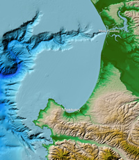
| Color hillshade of Monterey, CA coastal DEM |
Statement: High-resolution, integrated bathymetric-topographic relief models of U.S. coastal communities; 1/3 arc-second (~10 m) cell size and coarser
Abstract: NOAA's National Centers for Environmental Information (NCEI) builds and distributes high-resolution, coastal digital elevation models (DEMs) that integrate ocean bathymetry and land topography to support NOAA's mission to understand and predict changes in Earth's environment, and conserve and manage coastal and marine resources to meet our Nation's economic, social, and environmental needs. They can be used for modeling of coastal processes (tsunami inundation, storm surge, sea-level rise, contaminant dispersal, etc.), ecosystems management and habitat research, coastal and marine spatial planning, and hazard mitigation and community preparedness.
Bathymetric, topographic, and shoreline data used in DEM compilation are obtained from various sources, including NCEI, the U.S. National Ocean Service (NOS), the U.S. Geological Survey (USGS), the U.S. Army Corps of Engineers (USACE), the Federal Emergency Management Agency (FEMA), and other federal, state, and local government agencies, academic institutions, and private companies. DEMs cell size ranges from 1/9 arc-second (~3 meters) to 36 arc-seconds (~1 km).
Data format
| Data type: | Topography |
| Data origin: | Modeled |
| Data format: | GeoTIFF, NetCDF |
| Other format: | |
| Data resolution: | 1/9 arc-second (~3 meter) cell size and coarser |
| Datum: | NAD 83 or WGS 84 geographic (horizontal); NAVD 88 or MHW (vertical) |
Data Coverage
Spatial data coverage: U.S. coastal communities
Temporal data coverage: Time averaged
Time period covered: roughly 1950s to present
Availability
Download data: https://www.ngdc.noaa.gov/thredds/demCatalog.html
Data source: https://www.ngdc.noaa.gov/mgg/coastal/coastal.html
References
- Additional data access via NOAA Digital Coast Data Access Viewer
https://chs.coast.noaa.gov/htdata/raster2/elevation/NCEI_third_Topobathy_2014_8580/ https://chs.coast.noaa.gov/htdata/raster2/elevation/NCEI_ninth_Topobathy_2014_8483/
Metadata: https://data.noaa.gov/waf/NOAA/NESDIS/NGDC/MGG/DEM/iso/
