Data:3D Land Mapping
3D Land Mapping dataset information page
Short Description
 |
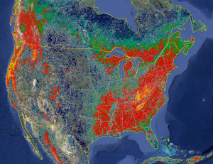
| Low resolution (10km) 3D Global Vegetation Map |
Statement: Combining Lidar and Radar for Remote Sensing of Land Surfaces
Abstract: The overall objective of the project is to combine radar and lidar remote sensing to characterize the forested landscapes in 3D. The science products generated by Simard and collaborators have four main components:
1 Global scale mapping of canopy height and biomass at 1km spatial resolution.
2 Improving Shuttle Radar Topography Mission (SRTM) elevation dataset using ICESat's Geoscience Laser Altimeter System (GLAS).
3 High spatial resolution mapping of canopy height and biomass using polarimeteric synthetic aperture radar interferometry (polinSAR) and LiDAR.
4 Mapping of mangrove forests canopy height, biomass, productivity and assessment of vulnerability to anthropogenic activity and sea level change.
Data format
| Data type: | Land Cover |
| Data origin: | Measured |
| Data format: | GeoTIFF |
| Other format: | |
| Data resolution: | 10km; 1km |
| Datum: | WGS1984 |
Data Coverage
Spatial data coverage: Global
Temporal data coverage: Time snap shot
Time period covered: 2000
Availability
Download data: https://landscape.jpl.nasa.gov/
Data source: https://landscape.jpl.nasa.gov/
