Talk:Marine Discussion
Discussion Page for the BP Oil Spill in the Gulf of Mexico
Introduction
The ongoing and uncontrolled release of oil from the Macondo well into the Gulf of Mexico, which began on April 20th, represents an ecological and economic crisis of unprecedented magnitude. Unlike most oil spills, which are predominantly two-dimensional surface events, this event has a distinctly three-dimensional character. This is partly due to the extreme conditions and chemistry that prevail at the well depth of 5000 feet (e.g. very high pressure and low temperature), the complex 3D pathways as oil travels over that distance and also because the heavy use of chemical dispersants has resulted in smaller droplets that rise very slowly. Largely due to the 3D character of this event, currently available models are not well-suited for predicting how this oil will move throughout the Gulf of Mexico and beyond. Indeed, the large plumes of oil that have been detected lingering at depths of 1500 and 3000 feet were not predicted by existing models (to our knowledge) and are still very poorly understood. These plumes represent an enormous volume of oil (estimated at roughly 4 miles by 10 miles by 600 feet), the ultimate fate of which is difficult to predict. As of June 3, 2010, all efforts to stop the flow from the Macondo well have failed and the "cut and cap" effort is underway. Two relief wells (3 miles below the seafloor) are also in progress but, if successful, are not expected to be completed until August 2010.
The purpose of this discussion page is to share information regarding this event that may be useful to CSDMS members who have an interest in modeling various aspects of it. For example, the NSF is making Rapid Response Research Grants (RAPID) available now for Gulf of Mexico oil spill research, see: http://www.nsf.gov/pubs/2010/nsf10060/nsf10060.jsp.
There are two leading "deep-water blowout" models which model the complex physics of deep-water releases of oil and gas such as this. They are called CDOG written by Dr. P. Yapa and colleagues and DeepBlow, written by Dr. Oistein Johansen. Unfortunately, neither of these is an open-source model.
CSDMS hosted a telecon on May 26th at 1 pm to discuss how our community might be able to contribute to efforts to model the oil spill and its environmental impact.
Model Forecasts and Animations
USF Ocean Circulation Group - Model Runs for the Gulf Oil Spill (Various Depths and Models)
http://ocgweb.marine.usf.edu/models.html
NOAA Office of Response and Restoration - Deepwater Horizon Incident Page & Current Trajectory Maps
http://response.restoration.noaa.gov/topic_subtopic_entry.php?
NCAR - Ocean currents likely to carry oil up Atlantic coast (July 3, 2010)
http://www2.ucar.edu/news/ocean-currents-likely-to-carry-oil-spill-to-atlantic-coast
List of Model Websites
ADCIRC Model:
http://adcirc.org/
CDOG Model:
http://www.cdogmodel.com/
FVCOM Model:
http://fvcom.smast.umassd.edu/FVCOM/index.html
HYCOM Model:
http://hycom.rsmas.miami.edu/hycom-model/modelcode.html
LTRANS Model (Larval TRANSport Lagrangian model)
http://northweb.hpl.umces.edu/LTRANS.htm
NCOM Model:
http://www7320.nrlssc.navy.mil/global_ncom/
NearCoM Model(s):
http://chinacat.coastal.udel.edu/programs/nearcom/index.html
ROMS Model:
http://www.myroms.org/
SHORECIRC Model (in NearCoM):
http://chinacat.coastal.udel.edu/programs/nearcom/descriptions/circulation_module_shorecirc.html
SLOSH Model (used by National Hurricane Center)
http://www.nhc.noaa.gov/HAW2/english/surge/slosh.shtml
NOAA Websites and Resources
NOAA Incident News Page - Deepwater Horizon Incident
http://www.incidentnews.gov/incident/8220
NOAA Office of Response and Restoration - Deepwater Horizon Incident Page & Current Trajectory Maps
long link, click here.
NOAA Office of Response and Restoration - Software and Data Sets Page
long link, click here
NOAA's GNOME Model:
long link, click here
NOAA's National Hurricane Center:
http://www.nhc.noaa.gov/HAW2/english/intro.shtml
Relevant Images and Movies
BP's website with numerous links and a live video feed:
http://www.bp.com/bodycopyarticle.do?categoryId=1&contentId=7052055
CNN's interactive oil spill tracker
http://www.cnn.com/2010/US/04/29/interactive.spill.tracker/index.html
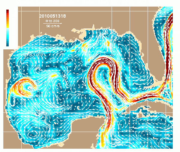
USF Ocean Circulation Group - Loop Current Simulation for 1 Month
(click here to play full-res animation):

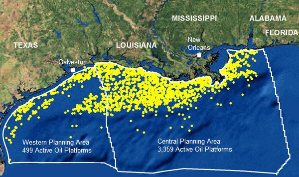
Map of oil rigs in the Gulf of Mexico :
(click here for full-resolution)

(from www.freerepublic.com/focus/news/2144025/posts)
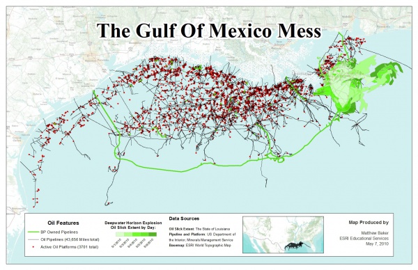
Oil pipelines and platforms in the Gulf of Mexico (click here for full-resolution)

(from www.democraticunderground.com/discuss/duboard.php?az=view_all&address=389x8385057)
Other Relevant Websites
Texas A & M University Library - Gulf of Mexico Oil Spill Page
(Many links to other online resources.)
http://library.tamu.edu/help/resource-format-guides/gulf-of-mexico-oil-spill
NASA Imagery of the Oil Spill:
http://earthobservatory.nasa.gov/NaturalHazards/event.php?id=43733
US Coast Guard Visual Information Gallery
http://cgvi.uscg.mil/media/main.php?g2_itemId=841811
ESRI Interactive Map for Gulf of Mexico Oil Spill
http://www.esri.com/services/disaster-response/gulf-oil-spill-2010/index.html
UNC Coastal Circulation and Transport Page:
http://www.unc.edu/ims/ccats/
Articles and Blogs
May 4, 2010: Washington Post - More Worst-Case Scenarios in Gulf Oil Spill
(With quotes from Dr. Rober Weisberg)
http://voices.washingtonpost.com/achenblog/2010/05/more_worst_case_scenarios_in_g.html?wprss=achenblog
May 5, 2010: Washington Post - After Gulf Coast oil spill, scientists envision devastation for region
http://www.washingtonpost.com/wp-dyn/content/article/2010/05/04/AR2010050402980.html?hpid=topnews
May 18, 2010: NY Times - Environment - The Oil and the Loop Current
http://green.blogs.nytimes.com/2010/05/18/the-oil-and-the-loop-current/?ref=science
May 18, 2010: TreeHugger Blog: Loop Current Now Dragging Gulf Oil Disaster Towards Florida Keys
http://www.treehugger.com/files/2010/05/loop-current-now-dragging-gulf-oil-disaster-florida-keys.php?campaign=th_
May 25, 2010: Blowout simulations and "trapping depth"
http://rucool.marine.rutgers.edu/deepwater/2010/05/blowout-simulations-and-trapping-depth/
June 1, 2010: 3 Questions: John Marshall on the Gulf of Mexico oil spill
http://www.physorg.com/news194629369.html
June 3, 2010: NCAR - Ocean currents likely to carry oil up Atlantic coast
http://www.dailycamera.com/news/ci_15219073
June 3, 2010: BP hits 'milestone' in capping well, but more work ahead
http://www.cnn.com/2010/US/06/03/gulf.oil.spill/index.html?hpt=T2
Relevant Publications
Dasanayaka, L.K. and P.D. Yapa (2009) Role of plume dynamics phase in a deepwater oil and gas release model, Journal of Hydro-environment Research, 2(4), 243-253.
Johansen, O. (2000) DeepBlow - A Lagrangian plume model for deep water blowouts, Spill Science & Technology Bull., 6(2), 103-111.
Johansen, O., H. Rye and C. Cooper (2003) DeepSpill - Field study of a simulated oil and gas blowout in deep water, Spill Science and Technology Bull., 8(5-6), 433-443.
Michel, J. and J.A. Galt (???) Conditions under which floating slicks can sink in marine settings, ****, ****.
Zheng, L., P.D. Yapa and F. Chen (2002) A model for simulating deepwater oil and gas blowouts - Part I. Theory and model formulation, Journal of Hydraulic Research, 41(4), 339-351.
