Meeting:Abstract 2011 CSDMS meeting-038
| You probably paid. If not: | 
|
"USA" is not in the list (Afghanistan, Albania, Algeria, Andorra, Angola, Antigua and Barbuda, Argentina, Armenia, Australia, Austria, ...) of allowed values for the "Country member" property.
Browse abstracts
Balazs Fekete choose to not submit an abstract for this conference.
[[Image:|300px|right|link=File:]]Riverine water transport is the dominant means of horizontal water delivery from headwaters to basin outlet in medium to large river basins. Travel time along river courses are primarily dictated by flow distances and channel properties, therefore the proper representation of the distance distribution from headwaters to basin mouth is a key for realistic flow routing. Gridded networks offer a simple and efficient rendition of the real river networks, but grid resolutions obviously affect the simulated networks' ability to capture river meandering.
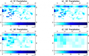
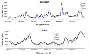
The width function of a river basin (that can be viewed as an approximation of the unit hydropgraph assuming uniform flow velocity) is an important metric evaluating gridded network. While several hundred grid cells are needed to reproduce the width function realistically the spatial accuracy of the runoff distribution appears to be less critical for river discharge simulations. Figure 1 shows precipitation data sets degraded from the original 15' spatial resolution to 30', 60' and 120' applied in a daily water balance/transport simulation of the Danube river basin at 6' resolution. The resulting hydrographs on Figure 2 show major deviation only using 120' resolution forcing. These results indicate that river networks act as an averaging integrator therefor the exact location of where the surplus runoff was generated is less critical than getting the distance distribution right. As a consequence, one can conclude that vertical water budget calculations can be performed at a significantly courser spatial resolution than the accompanying horizontal flow routing through simulated river networks.
The availability of high resolution gridded network and robust network regridding algorithms that are capable to derive coarser resolution networks from the same high resolution source allows the optimization of network resolution (and the corresponding computational expenses) to specific application needs. The presentation will demonstrate the relationship between the spatial resolution of the gridded network and the resulting discharge estimates and provide guidance for a range of potential applications.
| Varying the resolution of precipitation forcing in a 6' resolution, daily water balance/transport simulation |


