Labs portal: Difference between revisions
(→Labs) |
|||
| Line 12: | Line 12: | ||
|- | |- | ||
|valign=top|[[File:Glaciallobes.png | 200px | left ]] | |valign=top|[[File:Glaciallobes.png | 200px | left ]] | ||
|valign=top| '''Glacio-Hydrological | |valign=top| '''Glacio-Hydrological Processes''' | ||
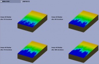
First steps in modeling glacial evolution within the CMT Tool. We use the 'GC2DV0'model to evolve a glacier in the Animas valley, Colorado. | First steps in modeling glacial evolution within the CMT Tool. We use the 'GC2DV0'model to evolve a glacier in the Animas valley, Colorado. | ||
[[media:GC2D Lab descriptionV2.pdf| PDF]] | [[media:GC2D Lab descriptionV2.pdf| PDF]] | ||
| Line 18: | Line 18: | ||
|- | |- | ||
|valign=top|[[File:RosettaLobe.png | 200px | left ]] | |valign=top|[[File:RosettaLobe.png | 200px | left ]] | ||
|valign=top| ''' | |valign=top| '''River-Delta Interactions''' | ||
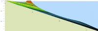
Explore river to delta interaction by coupling two models in the CMT Tool. We combine the 'Avulsion'model to mimick delta plain processes and combine this with the Coastline Evolution Model (CEM). | Explore river to delta interaction by coupling two models in the CMT Tool. We combine the 'Avulsion'model to mimick delta plain processes and combine this with the Coastline Evolution Model (CEM). | ||
[[media:RivertoDeltaModeling_lab5.pdf| PDF]] | [[media:RivertoDeltaModeling_lab5.pdf| PDF]] | ||
| Line 34: | Line 34: | ||
|valign=top| '''Landscape Evolution Numerical Experiments''' | |valign=top| '''Landscape Evolution Numerical Experiments''' | ||
''Wei Luo'' | ''Wei Luo'' | ||
WILSIM: the Web-based Interactive Landform Simulation Model shows landscape evolves under different conditions. It allows you to look at the effects of landscape geometry, climate and tectonics and see how a river network develops over time. WILSIM runs through your internet browser and can be accessed here: [http://www.niu.edu/landform/ WILSIM homepage]. | WILSIM: the Web-based Interactive Landform Simulation Model shows landscape evolves under different conditions. It allows you to look at the effects of landscape geometry, climate and tectonics and see how a river network develops over time. WILSIM runs through your internet browser and can be accessed here: [http://www.niu.edu/landform/ WILSIM homepage]. | ||
|- | |- | ||
|valign=top|[[File:Barsim.png | 200px | left | link= [[media:WAVECOASTPRACTICAL.zip]] ]] | |valign=top|[[File:Barsim.png | 200px | left | link= [[media:WAVECOASTPRACTICAL.zip]] ]] | ||
|valign=top| '''Coastal Stratigraphy | |valign=top| '''Coastal Stratigraphy Experiments''' | ||
Run a simple 2D barrier coast model. Focus is on exploration of the effects of external forcing factors, i.e. sediment supply and sea-level, on wave-dominated coasts and barrier islands. <br>[[media:WAVECOASTPRACTICAL.zip|zip archive with model and notes]] | Run a simple 2D barrier coast model. Focus is on exploration of the effects of external forcing factors, i.e. sediment supply and sea-level, on wave-dominated coasts and barrier islands. <br>[[media:WAVECOASTPRACTICAL.zip|zip archive with model and notes]] | ||
|- | |- | ||
|} | |} | ||
Revision as of 11:16, 13 May 2011
Labs
The freely downloadable labs are generously contributed by various people. Please make sure to credit the contributors when you are using these lectures. Want to contribute your own lab? Please contact irina.overeem@colorado.edu
| Labs | |
|---|---|
 |
Earth Science Models for K6-12
The PhET project at CU Boulder has built numerous interactive simulations to which CSDMS scientists contribute. These are for K6-12 classrooms! PhET Earth Science simulations are found here. |
| Glacio-Hydrological Processes
First steps in modeling glacial evolution within the CMT Tool. We use the 'GC2DV0'model to evolve a glacier in the Animas valley, Colorado. PDF | |
 |
River-Delta Interactions
Explore river to delta interaction by coupling two models in the CMT Tool. We combine the 'Avulsion'model to mimick delta plain processes and combine this with the Coastline Evolution Model (CEM). PDF |
 |
Sediment Supply to the Global Ocean
Investigate river sediment supply to the ocean by 1) a spreadsheet lab or 2) an advanced modeling lab using the HydroTrend Model to explore effects of climate changes on river fluxes. We also look at the effect of humans on rivers: the building of a reservoir. Spreadsheet Lab or the CMT Modeling Lab |
 |
Landscape Evolution Numerical Experiments
Wei Luo WILSIM: the Web-based Interactive Landform Simulation Model shows landscape evolves under different conditions. It allows you to look at the effects of landscape geometry, climate and tectonics and see how a river network develops over time. WILSIM runs through your internet browser and can be accessed here: WILSIM homepage. |
 |
Coastal Stratigraphy Experiments
Run a simple 2D barrier coast model. Focus is on exploration of the effects of external forcing factors, i.e. sediment supply and sea-level, on wave-dominated coasts and barrier islands. |
