|
|
| Line 1: |
Line 1: |
| ==Landscape Evolution Modeling with Child== | | ==Landscape Evolution Modeling with CHILD== |
|
| |
|
| If you have never used the Web Modeling Tool, learn how to use it [[WMT_tutorial|here]]. The WMT allows you to set up simulations, but once you are ready to run them, you will need an account on the CSDMS supercomputer to submit your job.
| | Authors: Gregory E. Tucker, University of Colorado Boulder, and Stephen T. Lancaster, Oregon State University |
| More information on getting an account can be found here [[HPCC_Access|Beach HPCC Access]]<br><br>
| | Date: These short course notes prepared for SIESD 2012: Future Earth: Interaction of Climate and Earth-surface Processes, |
| | University of Minnesota, Minneapolis, Minnesota, USA, August 2012. Notes and exercises updated for WMT by Stephanie |
| | Higgins, University of Colorado Boulder, August 2014. |
|
| |
|
| The Ganges-Brahmaputra Delta is one of the largest deltas in the world. In Bangladesh alone, 160 million people live in the floodplains. The Ganges and Brahmaputra Rivers and their delta are strongly impacted by the Asian summer monsoon. Widespread hazards relate to the intense seasonal rainfall: flooding, river erosion and channel switches. The people of Bangladesh have adapted to this dynamic delta system, they have raised villages above the annual flood level and embanked agricultural land.<br>
| | <br> |
| Still, the lowlands of the Ganges-Brahmaputra Delta are considered one of the regions most at risk from climate change, and particularly from sea level rise. About 75 million people live in the GB coastal zone (defined as the region <10 m.a.s.l). It is thought that the impact of relative sea-level change will be profound in Bangladesh where 32% of the country is already affected by tides, salinization, and cyclones/storm surges.
| | Before beginning these exercises, download the CHILD visualization tools [https://currently-broken-link-to-tools here] |
| At the same time, the Ganges-Brahmaputra river system drains tremendous amounts of sediment (sand, silt and clay) from its steep Himalayan hinterland. We ask: how does this amount of sediment change with a changing monsoonal climate? Does this sediment aggrade fast enough to help counteract rapid sea-level rise? <br><br>
| |
| [[File:GangesMap.png|600px]]
| |
| | |
| This lab investigates 1) the modeling of the incoming water and sediment load of the Ganges river, 2) the validity of model output compared to real-world observations, and 3) how future changes in the monsoon possibly affect this sedimentary system and 4) we try to assess the uncertainty of such predictions.
| |
| | |
| >> Open a new browser window and open the Web Modeling Tool [https://csdms.colorado.edu/wmt/WMT.html CSDMS WMT]<br>
| |
|
| |
|
| >> In WMT open the ‘public’ project ‘HydroTrend_Ganges’. <br>
| |
|
| |
|
| [[File:OpenExistingProject.png | load HydroTrend Ganges Project]].
| |
|
| |
|
| >> HydroTrend will now be active in the WMT. The HydroTrend Parameter list is set to be representative for the Ganges river basin. This pre-wired project can be saved to your own saved projects and submitted to Beach-the CSDMS High Performance Computing System. Provide your Beach account information (i.e. user name and password) to get the run started. The status page allows you to keep track of a simulation. From the status page you can eventually download your output files.
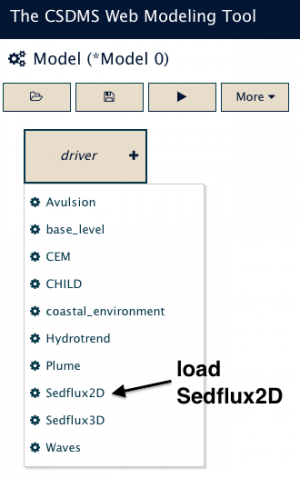
| | '''STEP1 Load the 2D Sedflux component''' |
| <br><br> | | <br><br> |
| | | >> If you have never used WMT, learn how to use it [[Labs_Basic_CMT|here]].<br> |
| '''Exercise 1: Explore the Ganges river simulation'''<br>
| | >> Pick SedFlux2D from the list of components in WMT<br> |
| | | >> SedFlux2D component is the sole driver of this simulation, so there is no need to assemble its ports.<br><br> |
| <br>
| | [[File:LoadSedflux2D_component.png|300px]] |
| >> Now save and run the simulation! Remember to refresh your browser to see how the run progresses.<br> | |
| >> Download the output files from the status window. Probably it is easiest to use the HydroTrend ASCII files, and then use Excell or Matlab to inquire the data. | |
| | |
| <br> | |
| Question 1a
| |
| Calculate mean water discharge Q, and the total annual water discharge Q.
| |
| Note all values in the file are reported as daily averages. Q= m3/s.
| |
| | |
| Question 1b
| |
| Jian et al., (2009) indicate the mean annual discharge of the Ganges river is observed as: Q=1.14 * 10<sup>4</sup> m<sup>3</sup>/sec (Jian et al., 2009).
| |
| How does the model prediction compare?
| |
| (''Jian, Webster, Hoyos, 2009. Large‐scale controls on Ganges and Brahmaputra river discharge on intraseasonal and seasonal time‐scales. Issue Quarterly Journal of the Royal Meteorological Society. 135, 639, 353–370'').
| |
| | |
| Question 1c
| |
| Calculate the mean annual sediment load for this river system.
| |
| Note that Cs=kg/m<sup>3</sup>, Qs= kg/s.
| |
| | |
| Question 1d
| |
| Generally reported in the early 1960’s that the two river systems contribute approximately equally in sediment.
| |
| (479 * 10<sup>6</sup> ton Ganges, 608 * 10<sup>6</sup> ton Brahmaputra) (Coleman, 1969)
| |
| Post-damming the estimate for the annual total is
| |
| (316 * 10<sup>6</sup> ton Ganges, 721 * 10<sup>6</sup> ton Brahmaputra) (Islam, 1999).
| |
| How does the total model predicted load compare? Do you think the observations are accurate?
| |
| | |
| | |
| '''Exercise 2: How does the Ganges river respond to future climate change''<br>
| |
| <br>
| |
| Climate model projection generally show an intensification of the Asian monsoon. This is thought to result in changes in rainfall over India, Nepal and Tibet, but model predictions are for large-scale patterns and suffer from uncertainty due to topographic effects.
| |
| | |
| >>Please try to find a precipitation estimate in the following paper: "Pervez and Henebry, 2014. Projections of the Ganges–Brahmaputra precipitation—Downscaled from GCM predictors. Journal of Hydrology 517 (2014) 120–134". Does the previously defined basin-average for the annual rainfall appear to be correct? What would precipitation amount to for 2000? What would it be for the Ganges for 2025 and 2050?
| |
| | |
| >>Use the WMT precipitation tabs to modify the mean annual precipitation P, and its the variability of the yearly means through the standard deviation. As we did in the general HydroTrend lab, you can specify trends over time, by modifying the parameter ‘change in mean annual precipitation’. In addition, you learned you can adapt seasonal trends by using the monthly values.
| |
| | |
| >> Set up a simulation for the Ganges river basin with an estimate for future precipitation based (a simulation of 2000-2050). Describe your strategy for doing so.
| |
| | |
| | |
| Question 2a
| |
| How does the predicted water and sediment load change?
| |
| How would you assess your uncertainty in the model predictions? Can you separately assess the error for the model input, and the error of the model equations? Describe how you would do this.
| |
| | |
| | |
| '''Exercise 3: How does the change in sediment flux affect aggradation'''<br>
| |
| | |
| Question 3
| |
| Can you make a back-of-the-envelop calculation to see how the change in sediment load affects the elevation of the GB delta. Use figure 2, assuming the distribution of sediment over the different zones remains similar. Is that a good assumption?
| |
| <br> | |
| [[File:SedimentDispersalGBsystem.png]] | |
| | |
| <br>
| |
Landscape Evolution Modeling with CHILD
Authors: Gregory E. Tucker, University of Colorado Boulder, and Stephen T. Lancaster, Oregon State University
Date: These short course notes prepared for SIESD 2012: Future Earth: Interaction of Climate and Earth-surface Processes,
University of Minnesota, Minneapolis, Minnesota, USA, August 2012. Notes and exercises updated for WMT by Stephanie
Higgins, University of Colorado Boulder, August 2014.
Before beginning these exercises, download the CHILD visualization tools here
STEP1 Load the 2D Sedflux component
>> If you have never used WMT, learn how to use it here.
>> Pick SedFlux2D from the list of components in WMT
>> SedFlux2D component is the sole driver of this simulation, so there is no need to assemble its ports.