Lab-0031: Difference between revisions
From CSDMS
(Created page with "{{Labbasics |Labtitle=Data Component Use Case for Landslide Susceptibility Calculation |LabCOModule=1 of 1 |LabDateContributedOrUpdated=2023-05-03 |LabDescriptionShort=A demonstration of how to use the Data Components to download topography and soil datasets to calculate the landslide susceptibility. |LabCODuration=1.5 hrs |LabURLDownloadNotebook=https://github.com/gantian127/landslide_usecase }} {{LabContributorData |LabContributorName=Tian Gan |LabContributorInstitute=...") |
No edit summary |
||
| Line 5: | Line 5: | ||
|LabDescriptionShort=A demonstration of how to use the Data Components to download topography and soil datasets to calculate the landslide susceptibility. | |LabDescriptionShort=A demonstration of how to use the Data Components to download topography and soil datasets to calculate the landslide susceptibility. | ||
|LabCODuration=1.5 hrs | |LabCODuration=1.5 hrs | ||
|LabModelDocumentation=None | |||
|LabURLDownloadNotebook=https://github.com/gantian127/landslide_usecase | |LabURLDownloadNotebook=https://github.com/gantian127/landslide_usecase | ||
}} | }} | ||
| Line 10: | Line 11: | ||
|LabContributorName=Tian Gan | |LabContributorName=Tian Gan | ||
|LabContributorInstitute=INSTAAR - University of Colorado Boulder. | |LabContributorInstitute=INSTAAR - University of Colorado Boulder. | ||
}} | |||
{{LabContributorData | |||
|LabContributorName=Benjamin Campforts | |||
|LabContributorInstitute=VU University Amsterdam | |||
}} | |||
{{LabContributorData | |||
|LabContributorName=Greg Tucker | |||
|LabContributorInstitute=Geological Sciences - University of Colorado Boulder | |||
}} | |||
{{LabContributorData | |||
|LabContributorName=Irina Overeem | |||
|LabContributorInstitute=Geological Sciences - University of Colorado Boulder | |||
}} | }} | ||
{{LabIntro | {{LabIntro | ||
| Line 16: | Line 29: | ||
}} | }} | ||
{{LabClassroomOrganization | {{LabClassroomOrganization | ||
|LabCOIntro=In this lab, | |LabCOIntro=Landslides are frequent hazards in Puerto Rico which are mainly caused by the steep terrain and heavy rainfall from hurricanes and other tropical weather systems. For example, Hurricane Maria hit the island of Puerto Rico on September 20th, 2017 and triggered more than 40,000 landslides in Puerto Rico (see details at https://www.usgs.gov/supplemental-appropriations-for-disaster-recovery-activities/landslides-triggered-hurricane-maria). | ||
In this lab, we will calculate the hourly landslide susceptibility for the area that has high concentration of landslide of Puerto Rico during Hurricane Maria. We will use the Topography and ERA5 Data Components to prepare the following datasets to calculate the landslide susceptibility. | |||
- OpenTopography DEM | |||
- ERA5 volumetric soil water and precipitation | |||
- Soil depth | |||
- Slope angle | |||
}} | }} | ||
{{LabLearningObjectivesSkills | {{LabLearningObjectivesSkills | ||
| Line 36: | Line 56: | ||
If you don't already have a JupyterHub account, follow the instructions to sign up at https://csdms.colorado.edu/wiki/JupyterHub. If you're an educator, you can get JupyterHub accounts for students--please contact us through the CSDMS Help Desk: https://csdms.github.io/help-desk. | If you don't already have a JupyterHub account, follow the instructions to sign up at https://csdms.colorado.edu/wiki/JupyterHub. If you're an educator, you can get JupyterHub accounts for students--please contact us through the CSDMS Help Desk: https://csdms.github.io/help-desk. | ||
|LabNotesRequirements=If run locally, please use the environment yaml file to create a virtual environment and run the notebook (https://github.com/gantian127/landslide_usecase/blob/master/environment.yml). | |LabNotesRequirements=If run locally, please use the environment yaml file to create a virtual environment and run the notebook (https://github.com/gantian127/landslide_usecase/blob/master/environment.yml). | ||
|LabAcknowledgements=This work was supported by the National Science Foundation under collaborative grants 1831623, 2026951, 2140831, 2104102, and 2148762. | |||
}} | |||
{{LabReferences | |||
|LabReferences=Strauch, R., Istanbulluoglu, E., Nudurupati, S. S., Bandaragoda, C., Gasparini, N. M., and Tucker, G. E. (2018), A hydroclimatological approach to predicting regional landslide probability using Landlab, Earth Surf. Dynam., 6, 49–75, https://doi.org/10.5194/esurf-6-49-2018 | |||
}} | |||
{{LabReferences | |||
|LabReferences=Montgomery, D. R., and Dietrich, W. E. (1994), A physically based model for the topographic control on shallow landsliding, Water Resour. Res., 30( 4), 1153– 1171, https://doi.org/10.1029/93WR02979. | |||
}} | }} | ||
Revision as of 17:47, 3 May 2023
Data Component Use Case for Landslide Susceptibility Calculation
Contributor(s)
Tian Gan at INSTAAR - University of Colorado Boulder..
Benjamin Campforts at VU University Amsterdam.
Greg Tucker at Geological Sciences - University of Colorado Boulder.
Irina Overeem at Geological Sciences - University of Colorado Boulder.
Introduction
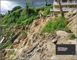

Landslide susceptibility is the likelihood of a landslide occurring in an area on the basis of local terrain condition to estimate “where” landslides are likely to occur. This lab demonstrates how to use several CSDMS data components to download topography and soil datasets to calculate the landslide susceptibility for a study area in Puerto Rico when Hurricane Maria hit the island in 2017. (Picture source: https://www.weather.gov/sju/maria2017)
Classroom organization
Landslides are frequent hazards in Puerto Rico which are mainly caused by the steep terrain and heavy rainfall from hurricanes and other tropical weather systems. For example, Hurricane Maria hit the island of Puerto Rico on September 20th, 2017 and triggered more than 40,000 landslides in Puerto Rico (see details at https://www.usgs.gov/supplemental-appropriations-for-disaster-recovery-activities/landslides-triggered-hurricane-maria).
In this lab, we will calculate the hourly landslide susceptibility for the area that has high concentration of landslide of Puerto Rico during Hurricane Maria. We will use the Topography and ERA5 Data Components to prepare the following datasets to calculate the landslide susceptibility.
- OpenTopography DEM
- ERA5 volumetric soil water and precipitation
- Soil depth
Learning objectives
Skills
Skills
- Learn to use Data Components to download research datasets
- Learn to create landslide susceptibility map
Key concepts
- Landslide Susceptibility
- CSDMS Data Component
Lab notes
This lab can be run on the lab (for educators) and jupyter (for general use) instances of the OpenEarthscape JupyterHub: just click one of the links under the Run online using heading at the top of this page, then run the notebook in the "CSDMS" kernel. If you don't already have a JupyterHub account, follow the instructions to sign up at https://csdms.colorado.edu/wiki/JupyterHub. If you're an educator, you can get JupyterHub accounts for students--please contact us through the CSDMS Help Desk: https://csdms.github.io/help-desk.
Requirements
If run locally, please use the environment yaml file to create a virtual environment and run the notebook (https://github.com/gantian127/landslide_usecase/blob/master/environment.yml).
Acknowledgements
This work was supported by the National Science Foundation under collaborative grants 1831623, 2026951, 2140831, 2104102, and 2148762.
References
- Strauch, R., Istanbulluoglu, E., Nudurupati, S. S., Bandaragoda, C., Gasparini, N. M., and Tucker, G. E. (2018), A hydroclimatological approach to predicting regional landslide probability using Landlab, Earth Surf. Dynam., 6, 49–75, https://doi.org/10.5194/esurf-6-49-2018
- Montgomery, D. R., and Dietrich, W. E. (1994), A physically based model for the topographic control on shallow landsliding, Water Resour. Res., 30( 4), 1153– 1171, https://doi.org/10.1029/93WR02979.
