Alldata:DBSEABED
DBSEABED dataset information page
Short Description
 |
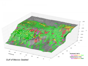
| Example data product - Seafloor classification, Northern Gulf of Mexico |
Statement: dbSEABED describes the materials and features of the global seafloor.
Abstract: dbSEABED is a Database/GIS that deals with the materials and features of the seabed. It holds data describing about 2 million seafloor sites. dbSEABED deals with the grain size textures, strengths and porosities, carbon and carbonate compositions, colors, structural features, and grain components of the seafloor. The scope of dbSEABED is global, from shoreline and continental shelf to the abyssal floor, addressing terrigenous-, volcanic- and biogenic-derived materials in their rock and sediment forms.
- This site publishes gridded outputs suitable for use in numerical models.
Data format
| Data type: | Substrates |
| Data origin: | Measured |
| Data format: | ASCII |
| Other format: | ESRI grid |
| Data resolution: | Usually 0.02 deg |
| Datum: | WGS84 |
Data Coverage
Spatial data coverage: Global point source measurements
Temporal data coverage: Time averaged
Time period covered:
Availability
Download data: http://csdms.colorado.edu/wiki/DBSEABED
Data source: http://instaar.colorado.edu/~jenkinsc/dbseabed/
References
- Cite as: Jenkins, C.J. 2010. Seafloor Substrates. INSTAAR, University of Colorado, Boulder CO USA. (URL: "http://csdms.colorado.edu/wiki/Data:DBSEABED"; Last edit 25Aug2013)
