|Labtitle=Data Component Use Case for Permafrost thaw and Hillslope iffusion
|Labtitle=Data Component Use Case for Permafrost Thaw and Hillslope Diffusion
|LabCOModule=1 of 1
|LabCOModule=1 of 1
|LabDateContributedOrUpdated=2023-05-04
|LabDateContributedOrUpdated=2023-05-04
Line 11:
Line 11:
|LabContributorName=Tian Gan
|LabContributorName=Tian Gan
|LabContributorInstitute=INSTAAR - University of Colorado Boulder
|LabContributorInstitute=INSTAAR - University of Colorado Boulder
}}
{{LabContributorData
|LabContributorName=Greg Tucker
|LabContributorInstitute=Geological Sciences - University of Colorado Boulder
}}
{{LabContributorData
|LabContributorName=Irina Overeem
|LabContributorInstitute=Geological Sciences - University of Colorado Boulder
}}
{{LabContributorData
|LabContributorName=Ethan Pierce
|LabContributorInstitute=Geological Sciences - University of Colorado Boulder
}}
}}
{{LabIntro
{{LabIntro
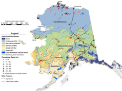
|LabDescription=Permafrost is defined as any material (rock or soil) that remains below 0°C for two or more consecutive years. This lab demonstrates how to use several CSDMS data components (https://csdms.colorado.edu/wiki/DataComponents) to download topography, snow and temperature data and couple them with the Model Components from Landlab and Pymt to calculate the permafrost active layer thickness and simulate the hillslope diffusion process for a study area in Alaska. (Picture source https://permafrost.gi.alaska.edu/sites/default/files/AlaskaPermafrostMap_Front_Dec2008_Jorgenson_etal_2008.pdf)
|LabDescription=Permafrost is defined as any material (rock or soil) that remains below 0°C for two or more consecutive years. This lab demonstrates how to use several CSDMS data components (https://csdms.colorado.edu/wiki/DataComponents) to download topography, snow and temperature data and couple them with the Model Components from Landlab and Pymt to calculate the permafrost active layer thickness and simulate the hillslope diffusion process for a study area in Alaska.
Classroom organization Permafrost covers nearly 85% of Alaska. A warming climate brought higher temperatures which may cause some permafrost to thaw. This can lead to geologic hazards such as landslides, ground subsidence, erosion and other severe surface distortions.
In this lab, we will use the Kudryavtsev (Ku) model to calculate the active layer thickness for a study area in Alaska. Active layer is the top layer of the permafrost where the annual maximum temperature reaches 0°C and the temperature shift over diurnal and seasonal cycles. Then we will use the active layer thickness as the input of the Landlab component (DepthDependentDiffuser) to simulate the hillslope diffusion process. The ERA5 and Topography Data Components are used to prepare the inputs for the Ku model.
Learning objectives Skills
Learn to use Data Components to download research datasets
Learn to couple Data and Model Components for simulation
Key concepts
Landlab
Pymt
CSDMS Data Component
Lab notes This lab can be run on the lab (for educators) and jupyter (for general use) instances of the OpenEarthscape JupyterHub: just click one of the links under the Run online using heading at the top of this page, then run the notebook in the "CSDMS" kernel.
Acknowledgements This work was supported by the National Science Foundation under collaborative grants 1831623, 2026951, 2140831, 2104102, and 2148762.