|LabDescriptionShort=A demonstration of how to use the Data Components and Landlab model components to simulate the overland flow process.
|LabDescriptionShort=A demonstration of how to use the Data Components and Landlab components for overland flow simulation.
|LabCODuration=1.5 hrs
|LabCODuration=1.5 hrs
|LabModelDocumentation=Landlab
|LabModelDocumentation=Landlab
Line 11:
Line 11:
{{LabContributorData
{{LabContributorData
|LabContributorName=Tian Gan
|LabContributorName=Tian Gan
|LabContributorInstitute=University of Colorado Boulder
|LabContributorInstitute=INSTAAR - University of Colorado Boulder
}}
{{LabContributorData
|LabContributorName=Greg Tucker
|LabContributorInstitute=Geological Sciences - University of Colorado Boulder
}}
{{LabContributorData
|LabContributorName=Irina Overeem
|LabContributorInstitute=Geological Sciences - University of Colorado Boulder
}}
}}
{{LabIntro
{{LabIntro
|LabDescription=Overland flow, particularly the infiltration-excess mechanism, is affected by the nature of water input through precipitation. This Jupyter notebook demonstrates how to use the CSDMS Data Components to download the topography dataset and use the Landlab components to delineate the watershed and simulate the overland flow for a study area in the Boulder County.
|LabDescription=Overland flow, particularly the infiltration-excess mechanism, is affected by the nature of water input through precipitation. This Jupyter notebook demonstrates how to use the CSDMS Data Components () to download the topography dataset and use the Landlab components to delineate the watershed and simulate the overland flow for a study area in the Boulder County.
|LabPicture=Overland flow.png
|LabPicture=Overland flow.png
}}
}}
{{LabClassroomOrganization
{{LabClassroomOrganization
|LabCOIntro=In this lab, you will learn how to use the Data Components to download terrain and climate datasets. You will also learn how to couple the Data Components with the Landlab components for watershed delineation and overland flow simulation.
|LabCOIntro=In this lab, you will learn how to use Topography and ERA5 Data Components to download terrain and precipitation datasets. You will also learn how to use the Landlab components (FlowAccumulator and ChannelProfiler) and the Landlab utility (get_watershed_mask) for watershed delineation and overland flow simulation.
}}
{{LabLearningObjectivesSkills
|LabSkill=Learn to use Python to create plots and movies
}}
}}
{{LabLearningObjectivesSkills
{{LabLearningObjectivesSkills
|LabSkill=Learn to use different Data Components
|LabSkill=Learn to use Data Components to download research datasets.
}}
}}
{{LabLearningObjectivesSkills
{{LabLearningObjectivesSkills
|LabSkill=Learn to couple Data and Model Components
|LabSkill=Learn to couple Data and Model Components for overland flow simulation.
}}
}}
{{Headerplaceholder}}
{{Headerplaceholder}}
Line 44:
Line 49:
If you don't already have a JupyterHub account, follow the instructions to sign up at https://csdms.colorado.edu/wiki/JupyterHub. If you're an educator, you can get JupyterHub accounts for students--please contact us through the CSDMS Help Desk: https://csdms.github.io/help-desk.
If you don't already have a JupyterHub account, follow the instructions to sign up at https://csdms.colorado.edu/wiki/JupyterHub. If you're an educator, you can get JupyterHub accounts for students--please contact us through the CSDMS Help Desk: https://csdms.github.io/help-desk.
|LabNotesRequirements=If run locally, please use the environment yaml file to create a virtual environment for running the notebook (https://github.com/gantian127/overlandflow_usecase/blob/master/environment.yml).
|LabNotesRequirements=If run locally, please use the environment yaml file to create a virtual environment and run the notebook (https://github.com/gantian127/overlandflow_usecase/blob/master/environment.yml).
|LabAcknowledgements=This material is based upon work supported by the National Science Foundation under Grant No. 1831623 and No. ,
|LabAcknowledgements=This work was supported by the National Science Foundation under collaborative grants 1831623, 2026951, 2140831, 2104102, and 2148762.
}}
}}
{{LabReferences
{{LabReferences
|LabReferences=Barnhart, K. R., Hutton, E. W. H., Tucker, G. E., M. Gasparini, N., Istanbulluoglu, E., E. J. Hobley, D., J. Lyons, N., Mouchene, M., Siddhartha Nudurupati, S., M. Adams, J., & Bandaragoda, C. (2020). Short communication: Landlab v2.0: A software package for Earth surface dynamics. Earth Surface Dynamics, 8(2), 379–397. https://doi.org/10.5194/esurf-8-379-2020!%5Bimage.png%5D
|LabReferences=Barnhart, K. R., Hutton, E. W. H., Tucker, G. E., M. Gasparini, N., Istanbulluoglu, E., E. J. Hobley, D., J. Lyons, N., Mouchene, M., Siddhartha Nudurupati, S., M. Adams, J., & Bandaragoda, C. (2020). Short communication: Landlab v2.0: A software package for Earth surface dynamics. Earth Surface Dynamics, 8(2), 379–397. https://doi.org/10.5194/esurf-8-379-2020
}}
}}
{{LabReferences
{{LabReferences
|LabReferences=de Almeida, G. A., Bates, P., Freer, J. E., & Souvignet, M. (2012). Improving the stability of a simple formulation of the shallow water equations for 2‐D flood modeling. Water Resources Research, 48(5).
|LabReferences=de Almeida, G. A., Bates, P., Freer, J. E., & Souvignet, M. (2012). Improving the stability of a simple formulation of the shallow water equations for 2‐D flood modeling. Water Resources Research, 48(5). https://doi.org/10.1029/2011WR011570
}}
}}
{{LabReferences
{{LabReferences
|LabReferences=Adams, J. M., Gasparini, N. M., Hobley, D. E. J., Tucker, G. E., Hutton, E. W. H., Nudurupati, S. S., and Istanbulluoglu, E.: The Landlab v1.0 OverlandFlow component: a Python tool for computing shallow-water flow across watersheds, Geosci. Model Dev., 10, 1645–1663, https://doi.org/10.5194/gmd-10-1645-2017, 2017.
|LabReferences=Adams, J. M., Gasparini, N. M., Hobley, D. E. J., Tucker, G. E., Hutton, E. W. H., Nudurupati, S. S., and Istanbulluoglu, E.: The Landlab v1.0 OverlandFlow component: a Python tool for computing shallow-water flow across watersheds, Geosci. Model Dev., 10, 1645–1663, https://doi.org/10.5194/gmd-10-1645-2017, 2017.
}}
}}
Revision as of 15:41, 3 May 2023
Data Component Use Case for Overland Flow Simulation
Tian Gan at INSTAAR - University of Colorado Boulder.
Greg Tucker at Geological Sciences - University of Colorado Boulder.
Irina Overeem at Geological Sciences - University of Colorado Boulder.
Introduction
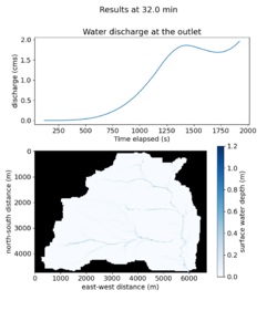
Overland flow, particularly the infiltration-excess mechanism, is affected by the nature of water input through precipitation. This Jupyter notebook demonstrates how to use the CSDMS Data Components () to download the topography dataset and use the Landlab components to delineate the watershed and simulate the overland flow for a study area in the Boulder County.
Classroom organization In this lab, you will learn how to use Topography and ERA5 Data Components to download terrain and precipitation datasets. You will also learn how to use the Landlab components (FlowAccumulator and ChannelProfiler) and the Landlab utility (get_watershed_mask) for watershed delineation and overland flow simulation.
Learning objectives Skills
Learn to use Data Components to download research datasets.
Learn to couple Data and Model Components for overland flow simulation.
Key concepts
Landlab
Data-Model Integration
CSDMS Data Component
Lab notes This lab can be run on the lab (for educators) and jupyter (for general use) instances of the OpenEarthscape JupyterHub: just click one of the links under the Run online using heading at the top of this page, then run the notebook in the "CSDMS" kernel.
Acknowledgements This work was supported by the National Science Foundation under collaborative grants 1831623, 2026951, 2140831, 2104102, and 2148762.
References
Barnhart, K. R., Hutton, E. W. H., Tucker, G. E., M. Gasparini, N., Istanbulluoglu, E., E. J. Hobley, D., J. Lyons, N., Mouchene, M., Siddhartha Nudurupati, S., M. Adams, J., & Bandaragoda, C. (2020). Short communication: Landlab v2.0: A software package for Earth surface dynamics. Earth Surface Dynamics, 8(2), 379–397. https://doi.org/10.5194/esurf-8-379-2020
de Almeida, G. A., Bates, P., Freer, J. E., & Souvignet, M. (2012). Improving the stability of a simple formulation of the shallow water equations for 2‐D flood modeling. Water Resources Research, 48(5). https://doi.org/10.1029/2011WR011570
Adams, J. M., Gasparini, N. M., Hobley, D. E. J., Tucker, G. E., Hutton, E. W. H., Nudurupati, S. S., and Istanbulluoglu, E.: The Landlab v1.0 OverlandFlow component: a Python tool for computing shallow-water flow across watersheds, Geosci. Model Dev., 10, 1645–1663, https://doi.org/10.5194/gmd-10-1645-2017, 2017.