Topography data descriptions
This is an automatically generated table.
Want to add your dataset to this list? Please complete this data form first. Feel free to contact us CSDMSweb@colorado.edu or use the wiki and follow one of the dataset links if you want to update the information about a dataset that is already listed.
There are 23 datasets described below.
| Dataset info | Type | Origin | Description | Data example |
|---|---|---|---|---|
| ASTER | Topography | Measured | Global topography from NASA's and METI's (Japan) Terra satellite | 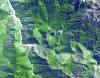 |
| Aerial images Fraser GST | Topography | Measured | Aerial images of Fraser GST zone | 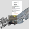 |
| CGIAR-CSI SRTM | Topography | Modeled | Improved and void-filled global topographic model of the SRTM data; 3 arc-second (~90 m) cell size | |
| Clara Orru - measured data of a degradational sand-gravel laboratory experiment | Topography | Measured | measured data from a degradational sand-gravel laboratory experiment |  |
| Coastal DEMs | Topography | Modeled | High-resolution, integrated bathymetric-topographic relief models of U.S. coastal communities; 1/3 arc-second (~10 m) cell size and coarser | 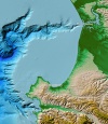 |
| ETOPO1 | Topography | Modeled | Global integrated bathymetric-topographic relief model; 1 arc-minute (~2 km) cell size | 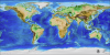 |
| GEBCO | Topography | Modeled | Global integrated bathymetric-topographic relief model; 1 arc-minute (~2 km) and 30 arc-second (~1 km) cell sizes | 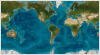 |
| GLOBE | Topography | Modeled | Global topographic relief model; 30 arc-second (~1 km) cell size |  |
| GSHHG | Topography | Measured | Global Self-consistent, Hierarchical, High-resolution Geography Database |
 |
| GTOPO30 | Topography | Modeled | GTOPO30 is a global digital elevation model with a horizontal resolution of 30 arc seconds. | 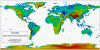 |
| Global Multibeam Bathymetry | Topography | Measured | NGDC's global database of multibeam swath sonar bathymetric surveys |  |
| Global Topography | Topography | Modeled | Global estimated bathymetric and integrated bathy-topo relief models; 1 minute (~2 km) and 30 arc-second (~1 km) cell sizes | 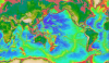 |
| Great Lakes Bathymetry | Topography | Modeled | Bathymetric models and contours of the Great Lakes; 3 arc-second (~90 m) cell size |  |
| IBCAO | Topography | Modeled | Integrated bathymetric-topographic relief model of the Arctic Ocean; 500-meter cell size | 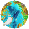 |
| MERIT DEM | Topography | Measured | The MERIT DEM was developed by removing multiple error components from existing spaceborne DEMs (SRTM3 and AW3D) | 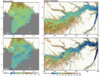 |
| Marine Geophysical Trackline Data | Topography | Measured | NGDC's global database of marine trackline surveys; contains bathymetry, magnetics, gravity and seismic navigation data | 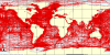 |
| NED | Topography | Modeled | U.S. National Elevation Dataset (NED) topographic relief model; 1/9 arc-second (~3 m) cell size to 2 arc-second (~60 m) cell size | 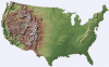 |
| NGDC Coastal Relief Model | Topography | Modeled | Integrated bathymetric-topographic relief models of U.S. coasts; 3 arc-second (~90 m) cell size | 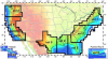 |
| NOSHDB | Topography | Measured | Database of U.S. hydrographic surveys conducted by NOAA's National Ocean Service | 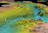 |
| OpenTopography | Topography | Modeled | Community access to high-resolution, Earth science-oriented, topography data, and related tools and resources. | 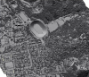 |
| SRTM | Topography | Measured | Global topography from NASA's 2000 Shuttle Radar Topography Mission (SRTM) | 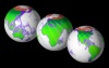 |
| Southern Alaska Coastal Relief Model | Topography | Modeled | Integrated bathymetric-topographic relief model of Southern Alaska; 24 arc-second cell size | |
| World Vector Shoreline | Topography | Measured | World Vector Shoreline |  |
