File:Resuspension.gif
Original file (1,250 × 800 pixels, file size: 47.15 MB, MIME type: image/gif, looped, 80 frames, 10 s)
Note: Due to technical limitations, thumbnails of high resolution GIF images such as this one will not be animated.
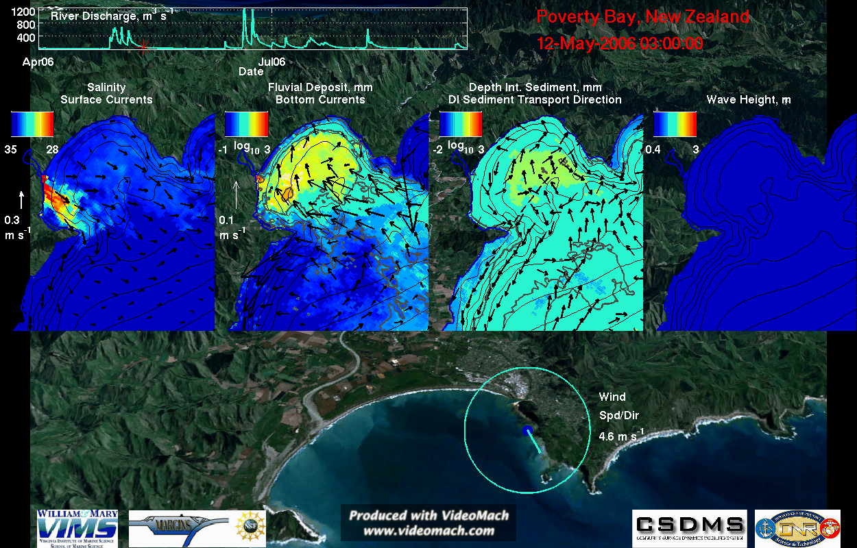
This is a visualization of coupled ROMS-SWAN results for a wave resuspension period. The visualization highlights the sediment export from Poverty Bay, caused by sediment resuspension from Southern Ocean swell waves. Hydrodynamics, sediment-transport, waves, wind, and river discharge are shown.
This visualization contains four main panels showing the currents, sediment-transport, and waves overtop a satellite photograph from World Wind of Poverty Bay and the Waipaoa River flood plain. These panels, from left to right, have the bathymetry contoured every 5 meters from 5 to 45 m and show the:
- 1) Surface salinity (colors) and surface currents (arrows): The white arrow to the left of the panel is a scale arrow for the currents. This panel also contains the location and travel paths for lagrangian floats initialized every 2 days in the surface waters of Poverty Bay.
- 2) Fluvial sediment deposition (colors) and bottom currents (arrows): The white arrow to the left of the panel is a scale arrow for the currents. Sediment deposition is shown on a log10 scale in units of kg m-2, with 0, 1, and 2 contoured in grey. When a porosity of ~65% is assumed, these units are equivalent to millimeters of thickness. This panel also contains the location and travel paths for lagrangian floats initialized every 2 days in the bottom waters of Poverty Bay.
- 3) Depth-integrated fluvial suspended sediment within the water column (colors) and the depth-integrated sediment-transport direction (arrows): The depth-integrated suspended sediment is shown on a log10 scale with 1, 2, and 3 contoured in grey, and is the amount of sediment that would be deposited on the seabed if all the sediment within the water column immediately settled out, with the same units as panel 2. The depth-integrated sediment transport was deemed negligible and the arrows not shown when it was less than 0.04 kg m-1 s-1.
- 4) Significant wave height: The locations of three current vertical profiles explained below are shown with the stars.
Other features of the visualization are the:
- Waipaoa River discharge: A time-series of the freshwater discharge was provided in the top left corner of the visualization. A red star on this progresses with time. Discharge data was from the Kanakanaia Bridge about 48 km from the river mouth.
- Time-stamp: The date and time are provided in the upper right corner
- Winds: Beneath the four main panels is the wind speed and direction. The arrow points in the direction toward which the wind blew and scales with the wind speed, which is also provided in the text to the right of the circle.
File history
Click on a date/time to view the file as it appeared at that time.
| Date/Time | Thumbnail | Dimensions | User | Comment | ||
|---|---|---|---|---|---|---|
| delete all | current | 08:16, 10 November 2010 | | 1,250 × 800 (47.15 MB) | Abever (talk | contribs) | This is a visualization of coupled ROMS-SWAN results for a wave resuspension period. The visualization highlights the sediment export from Poverty Bay, caused by sediment resuspension from Southern Ocean swell waves. Hydrodynamics, sediment-transport, wav |
You cannot overwrite this file.
File usage
The following page uses this file:
