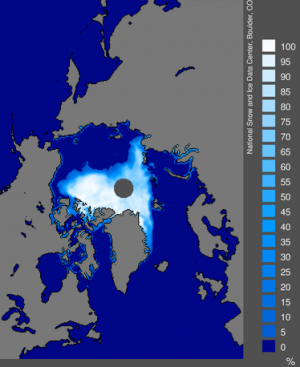
Data:Sea Ice Concentrations NSIDC
Sea Ice Concentrations NSIDC dataset information page
Short Description
| Sea Oce Concentration 09/2007 |
Statement: Sea Ice Concentrations from Nimbus-7 SMMR and DMSP SSM/I Passive Microwave Data
Abstract: This data set is generated from brightness temperature data derived from Nimbus-7 Scanning Multichannel Microwave Radiometer (SMMR) and Defense Meteorological Satellite Program (DMSP) -F8, -F11 and -F13 Special Sensor Microwave/Imager (SSM/I) radiances at a grid cell size of 25 x 25 km. The data are provided in the polar stereographic projection.
This product is designed to provide a consistent time series of sea ice concentrations (the fraction, or percentage, of ocean area covered by sea ice) spanning the coverage of several passive microwave instruments. To aid in this goal, sea ice algorithm coefficients are changed to reduce differences in sea ice extent and area as estimated using the SMMR and SSM/I sensors. The data are generated using the NASA Team algorithm developed by the Oceans and Ice Branch, Laboratory for Hydrospheric Processes at NASA Goddard Space Flight Center (GSFC).
These data include gridded daily (every other day for SMMR data) and monthly averaged sea ice concentrations for both the north and south polar regions. Two types of data are provided: final data and preliminary data. Final data are produced at GSFC about once per year, with roughly a one-year latency, and include data since 26 October 1978. Final data are produced from SMMR brightness temperature data processed at NASA GSFC and SSM/I brightness temperature data processed at the National Snow and Ice Data Center (NSIDC). Preliminary data are produced at NSIDC approximately every three months (quarterly), using SSM/I data acquired from Remote Sensing Systems, Inc. (RSS), and include roughly the most recent three to twelve months of processed data.
Data are scaled and stored as one-byte integers in flat binary arrays.
Data format
| Data type: | Cryosphere |
| Data origin: | Measured |
| Data format: | Binary |
| Other format: | |
| Data resolution: | 25 * 25 km |
| Datum: | Polar stereographic projection |
Data Coverage
Spatial data coverage: North and south polar regions
Temporal data coverage: Time series
Time period covered: October 26th, 1978 - present
Availability
Download data: http://nsidc.org/data/nsidc-0051.html
Data source: http://nsidc.org/data/nsidc-0051.html
References
- Cavalieri, D., C. Parkinson, P. Gloersen, and H. J. Zwally. 1996, updated 2008. Sea ice concentrations from Nimbus-7 SMMR and DMSP SSM/I passive microwave data, "list dates of temporal coverage used". Boulder, Colorado USA: National Snow and Ice Data Center. Digital media.
- Meier, W., F. Fetterer, K. Knowles, M. Savoie, M. J. Brodzik. 2006, updated quarterly. Sea ice concentrations from Nimbus-7 SMMR and DMSP SSM/I passive microwave data, "list dates of temporal coverage used". Boulder, Colorado USA: National Snow and Ice Data Center. Digital media.

