Data:IBCAO: Difference between revisions
No edit summary |
No edit summary |
||
| Line 1: | Line 1: | ||
{{Data description | {{Data description | ||
|One-line data description=Integrated | |One-line data description=Integrated bathymetric-topographic DEM of the Arctic Ocean; 500-meter cell size | ||
|Extended data description=International Bathymetric Chart of the Arctic Ocean (IBCAO). The goal of this initiative is to develop a digital data base that contains all available bathymetric data north of 64 degrees North, for use by mapmakers, researchers, and others whose work requires a detailed and accurate knowledge of the depth and the shape of the Arctic seabed. | |Extended data description=International Bathymetric Chart of the Arctic Ocean (IBCAO). The goal of this initiative is to develop a digital data base that contains all available bathymetric data north of 64 degrees North, for use by mapmakers, researchers, and others whose work requires a detailed and accurate knowledge of the depth and the shape of the Arctic seabed. | ||
IBCAO Version 3.0 represents the largest improvement since 1999 taking advantage of new data sets collected by the circum-Arctic nations, opportunistic data collected from fishing vessels, data acquired from US Navy submarines and from research ships of various nations. Built using an improved gridding algorithm, this new grid is on a 500 meter spacing, revealing much greater details of the Arctic seafloor than IBCAO Version 1.0 (2.5 km) and Version 2.0 (2.0 km). The area covered by multibeam surveys has increased from ~6 % in Version 2.0 to ~11% in Version 3.0. | IBCAO Version 3.0 represents the largest improvement since 1999 taking advantage of new data sets collected by the circum-Arctic nations, opportunistic data collected from fishing vessels, data acquired from US Navy submarines and from research ships of various nations. Built using an improved gridding algorithm, this new grid is on a 500 meter spacing, revealing much greater details of the Arctic seafloor than IBCAO Version 1.0 (2.5 km) and Version 2.0 (2.0 km). The area covered by multibeam surveys has increased from ~6 % in Version 2.0 to ~11% in Version 3.0. | ||
|Upload image dataset=IBCAO.png | |Upload image dataset=IBCAO.png | ||
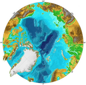
|Caption dataset image=Color hillshade of Arctic Ocean bathymetry | |Caption dataset image=Color hillshade of Arctic Ocean bathymetry | ||
| Line 24: | Line 24: | ||
}} | }} | ||
{{Data references | {{Data references | ||
|Key references dataset=Jakobsson, M., L. A. Mayer, B. Coakley, J. A. Dowdeswell, S. Forbes, B. Fridman, H. Hodnesdal, R. Noormets, R. Pedersen, M. Rebesco, H.-W. Schenke, Y. Zarayskaya A, D. Accettella, A. Armstrong, R. M. Anderson, P. Bienhoff, A. Camerlenghi, I. Church, M. Edwards, J. V. Gardner, J. K. Hall, B. Hell, O. B. Hestvik, Y. Kristoffersen, C. Marcussen, R. Mohammad, D. Mosher, S. V. Nghiem, M. T. Pedrosa, P. G. Travaglini, and P. Weatherall, The International Bathymetric Chart of the Arctic Ocean (IBCAO) Version 3.0, Geophysical Research Letters, doi: 10.1029/2012GL052219. | |Key references dataset=Jakobsson, M., L. A. Mayer, B. Coakley, J. A. Dowdeswell, S. Forbes, B. Fridman, H. Hodnesdal, R. Noormets, R. Pedersen, M. Rebesco, H.-W. Schenke, Y. Zarayskaya A, D. Accettella, A. Armstrong, R. M. Anderson, P. Bienhoff, A. Camerlenghi, I. Church, M. Edwards, J. V. Gardner, J. K. Hall, B. Hell, O. B. Hestvik, Y. Kristoffersen, C. Marcussen, R. Mohammad, D. Mosher, S. V. Nghiem, M. T. Pedrosa, P. G. Travaglini, and P. Weatherall, The International Bathymetric Chart of the Arctic Ocean (IBCAO) Version 3.0, Geophysical Research Letters, doi: 10.1029/2012GL052219. | ||
}} | }} | ||
Revision as of 11:08, 24 March 2013
IBCAO dataset information page
Short Description
| Color hillshade of Arctic Ocean bathymetry |
Statement: Integrated bathymetric-topographic DEM of the Arctic Ocean; 500-meter cell size
Abstract: International Bathymetric Chart of the Arctic Ocean (IBCAO). The goal of this initiative is to develop a digital data base that contains all available bathymetric data north of 64 degrees North, for use by mapmakers, researchers, and others whose work requires a detailed and accurate knowledge of the depth and the shape of the Arctic seabed.
IBCAO Version 3.0 represents the largest improvement since 1999 taking advantage of new data sets collected by the circum-Arctic nations, opportunistic data collected from fishing vessels, data acquired from US Navy submarines and from research ships of various nations. Built using an improved gridding algorithm, this new grid is on a 500 meter spacing, revealing much greater details of the Arctic seafloor than IBCAO Version 1.0 (2.5 km) and Version 2.0 (2.0 km). The area covered by multibeam surveys has increased from ~6 % in Version 2.0 to ~11% in Version 3.0.
Data format
| Data type: | Topography |
| Data origin: | Modeled |
| Data format: | ArcExport, KMZ, NetCDF |
| Other format: | |
| Data resolution: | 500 meter cell size |
| Datum: | Polar stereographic projection, geographic (horizontal); MSL (vertical) |
Data Coverage
Spatial data coverage: Bathymetric data north of 64 degrees North
Temporal data coverage: Time averaged
Time period covered: up to the present
Availability
Download data: http://www.ngdc.noaa.gov/mgg/bathymetry/arctic/downloads.html
Data source: http://www.ngdc.noaa.gov/mgg/bathymetry/arctic/
References
- Jakobsson, M., L. A. Mayer, B. Coakley, J. A. Dowdeswell, S. Forbes, B. Fridman, H. Hodnesdal, R. Noormets, R. Pedersen, M. Rebesco, H.-W. Schenke, Y. Zarayskaya A, D. Accettella, A. Armstrong, R. M. Anderson, P. Bienhoff, A. Camerlenghi, I. Church, M. Edwards, J. V. Gardner, J. K. Hall, B. Hell, O. B. Hestvik, Y. Kristoffersen, C. Marcussen, R. Mohammad, D. Mosher, S. V. Nghiem, M. T. Pedrosa, P. G. Travaglini, and P. Weatherall, The International Bathymetric Chart of the Arctic Ocean (IBCAO) Version 3.0, Geophysical Research Letters, doi: 10.1029/2012GL052219.

