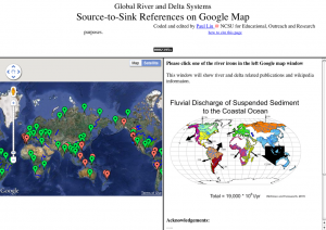
Data:Global River and Delta Systems
From CSDMS
Global River and Delta Systems dataset information page
Short Description
| Impression from the website |
Statement: Global River and Delta Systems
Abstract: A web portal for Global River and Delta Systems, Source-to-Sink references on google map. The underlying database contains for a selected set of rivers their length, basin area, water discharge, sediment load, sediment yield, delta size, related publications and an elevation profile of each of the selected rivers.
Data format
| Data type: | River discharge |
| Data origin: | Measured |
| Data format: | ASCII |
| Other format: | |
| Data resolution: | |
| Datum: |
Data Coverage
Spatial data coverage: World
Temporal data coverage: Time averaged
Time period covered: variable, decades to century
Availability
Download data: http://www.meas.ncsu.edu/sealevel/s2s/
Data source: http://www.meas.ncsu.edu/sealevel/s2s/
References
- Liu, J.P., 2011. Global River and Delta Systems Source-to-Sink References on Google Map. URL: http://www.meas.ncsu.edu/sealevel/s2s/ , accessed on yyyy-mm-dd (2011-03-03).

