GIMMS dataset information page
Short Description
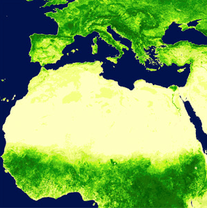
| Example of GIMMS data |
Statement: Global Inventory Modeling and Mapping Studies (GIMMS)
Abstract: The GIMMS (Global Inventory Modeling and Mapping Studies) data set is a normalized difference vegetation index (NDVI) product available for a 25 year period spanning from 1981 to 2006. The data set is derived from imagery obtained from the Advanced Very High Resolution Radiometer (AVHRR) instrument onboard the NOAA satellite series 7, 9, 11, 14, 16 and 17. This is an NDVI dataset that has been corrected for calibration, view geometry, volcanic aerosols, and other effects not related to vegetation change.
Data format
| Data type: | Land Cover |
| Data origin: | Measured |
| Data format: | GeoTIFF, MrSID, Shapefile |
| Other format: | HDF, BSQ, ArcGrid |
| Data resolution: | 4km |
| Datum: |
Data Coverage
Spatial data coverage: Global
Temporal data coverage: Time series
Time period covered: 1981 - 2006
Availability
Download data: https://iridl.ldeo.columbia.edu/SOURCES/.UMD/.GLCF/.GIMMS/.NDVIg/.global/.dataset documentation.html
Data source: https://iridl.ldeo.columbia.edu/SOURCES/.UMD/.GLCF/.GIMMS/.NDVIg/.global/.dataset documentation.html
References
- Tucker, C.J., J.E. Pinzon, and M.E. Brown (2004), Global Inventory Modeling and Mapping Studies, NA94apr15b.n11-VIg, 2.0, Global Land Cover Facility, University of Maryland, College Park, Maryland, 04/15/1994.
- Pinzon, J., Brown, M.E. and Tucker, C.J., 2005. Satellite time series correction of orbital drift artifacts using empirical mode decomposition. In: N. Huang (Editor), Hilbert-Huang Transform: Introduction and Applications, pp. 167-186.
- Tucker, C.J., J. E. Pinzon, M. E. Brown, D. Slayback, E. W. Pak, R. Mahoney, E. Vermote and N. El Saleous (2005), An Extended AVHRR 8-km NDVI Data Set Compatible with MODIS and SPOT Vegetation NDVI Data. International Journal of Remote Sensing, Vol 26:20, pp 4485-5598.

