Data:Coastal DEMs: Difference between revisions
From CSDMS
(Created page with "{{Data description |One-line data description=High-resolution, integrated bathymetric-topographic DEMs of U.S. coastal communities |Upload image dataset=Integrated coastal DEM...") |
No edit summary |
||
| Line 10: | Line 10: | ||
|Other data format=Arc ASCII | |Other data format=Arc ASCII | ||
|Data resolution=1/3 arc-second (~10 meter) cell size | |Data resolution=1/3 arc-second (~10 meter) cell size | ||
|Data projection=WGS 84 geographic (horizontal); NAVD 88 | |Data projection=WGS 84 geographic (horizontal); NAVD 88 or MHW (vertical) | ||
}} | }} | ||
{{Dataset coverage | {{Dataset coverage | ||
Revision as of 09:57, 24 March 2013
Coastal DEMs dataset information page
Short Description
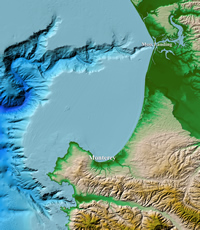
| Color hillshade of Monterey, CA coastal DEM |
Statement: High-resolution, integrated bathymetric-topographic DEMs of U.S. coastal communities
Abstract:
Data format
| Data type: | Topography |
| Data origin: | Modeled |
| Data format: | NetCDF |
| Other format: | Arc ASCII |
| Data resolution: | 1/3 arc-second (~10 meter) cell size |
| Datum: | WGS 84 geographic (horizontal); NAVD 88 or MHW (vertical) |
Data Coverage
Spatial data coverage: U.S. coastal communities
Temporal data coverage: Time averaged
Time period covered: roughly 1950s to present
Availability
Download data: http://www.ngdc.noaa.gov/mgg/coastal/
Data source: http://www.ngdc.noaa.gov/mgg/bathymetry/hydro.html

