CSDMS 2016 annual meeting poster MitchellDonovan
Temporal changes in channel migration and the influence of temporal measurement-scale
Patrick Belmont, Utah State University Logan Utah, United States.
Bastiaan Notebaert, University of Leuven - KU Leuven Leuven , Belgium.
Abstract:
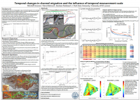
Increased availability of landscape-scale aerial photography and high-resolution topography (HRT) have enabled scientists to document landscape and riverine change over broad spatial and temporal scales. Contemporary geomorphic research has focused on fluvial changes and their connection to anthropogenic land-use shifts using aerial photographs and HRT. However, the community has overlooked the impact of temporal and spatial measurement scales in results, and thus, inferences on measured geomorphic change. Biases resulting from different temporal measurement scales have resulted in false conclusions for research on sedimentation rates (Sadler, 1981; Gardner et al., 1987). As the uprising of historical and contemporary datasets aid our attempts to understand landscape-scale changes over the past century, we must discern new obstacles in our haste to utilize such unique datasets. As researchers increasingly utilize the combination of historical and contemporary datasets, we must discern biases arising from differing measurement scales in order to avoid widespread fallacies in studies relating anthropogenic and fluvial change. Analyzing 11 sets of aerial photographs for measurements of lateral migration over space and time indicates that migration rates do not exhibit a systematic shift over time, but specific river zones are relatively more active. Furthermore, measurement-scale biases indeed arise from the time elapsed between measurements. Future work will combines these results with previously published datasets of lateral migration (based on aerial photographs) to answer whether such scaling effects are similar for all datasets, and if a universal scaling principle may be adopted for such measurements of channel change.
* Please acknowledge the original contributors when you are using this material. If there are any copyright issues, please let us know and we will respond as soon as possible.
