CSDMS 2016 annual meeting poster KatherineRatliff
Exploring delta morphodynamics with a coupled river-ocean model
Eric Hutton, CSDMS Boulder CO Colorado, United States. eric.hutton@colorado.edu
Brad Murray, Duke University Durham North Carolina, United States. abmurray@duke.edu
Abstract:
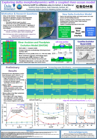
Often densely populated, deltas are important for agriculture, resource extraction, and transportation, yet they are increasingly vulnerable to natural disasters (e.g., flooding, storm surges) and submergence. Many natural processes influence large-scale delta morphology, yet the relative importance of anthropogenic influences in shaping modern deltas is unknown. To explore the long-term combined effects of sea-level rise, climate change, and anthropogenic influences, we have developed a new morphodynamic delta model that links fluvial, floodplain, and coastal dynamics over large space and timescales. Using the CSDMS Basic Modeling Interface, we couple the River Avulsion and Floodplain Evolution Model (RAFEM) with the Coastline Evolution Model (CEM). In RAFEM, the river course is determined using steepest-descent methodology, and elevation changes along the river profile are modeled as a linear diffusive process. An avulsion occurs when the riverbed becomes super-elevated relative to the surrounding floodplain, but only if the new steepest-descent path to sea level is shorter than the prior river course. CEM uses alongshore sediment transport gradients to distribute sediment flux from the river mouth along the coastline. Preliminary results indicate that anthropogenic manipulations of the river (e.g., levees) can propagate hundreds of kilometers upstream and affect shoreline morphology. Climate change impacts on delta morphology are modeled through changing storminess (affecting the wave climate) and varying sea-level rise rates.
* Please acknowledge the original contributors when you are using this material. If there are any copyright issues, please let us know and we will respond as soon as possible.
