CSDMS 2014 annual meeting poster Andrew Wickert
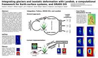
Integrating glaciers and isostatic deformation into Landlab, a computational framework for Earth-surface systems
William Colgan, Geological Survey of Denmark and Greenland Copenhagen , Denmark. william.colgan@colorado.edu
Leif Anderson, University of Colorado Boulder Colorado, United States. leif.anderson@colorado.edu
Daniel Hobley, University of Colorado Boulder Colorado, United States. daniel.hobley@colorado.edu
Robert Anderson, University of Colorado Boulder Colorado, United States. robert.s.anderson@colorado.edu
Gregory Tucker, University of Colorado Boulder Colorado, United States. gtucker@colorado.edu
Abstract:
Landlab is a new modeling framework to integrate components of the Earth-surface system and understand their interactions. Here we add two new components: (1) a mechanical ice flow model and (2) a model of Earth's flexural isostatic response to surface loads. The two are fully coupled, as large ice masses produce significant deflections of the surface. The mechanical ice flow model calculates 2D (depth-averaged) horizontal ice fluxes in response to an evolving surface mass balance parameterization and prescribed isothermal ice temperature. Solving depth-integrated ice velocity under prescribed ice temperature provides sufficient computational efficiency, relative to a fully 3D thermo-mechanical ice flow model, to explore glacier form and flow on geologic timescales. The flexure model ingests load distributions and a prescribed map of lithospheric elastic thickness to produce surface deflections. These connect with GRASS GIS to act as a database and platform for data–model integration and bypass the need to prepare input files. We explore the fully-transient interplay between ice overburden and lithospheric flexure using as a case study the evolution of the Yellowstone ice cap over the last glacial cycle, which covered an area of ~40,000 km2 at the Last Glacial Maximum (~26.5–19.5 ka).
* Please acknowledge the original contributors when you are using this material. If there are any copyright issues, please let us know and we will respond as soon as possible.
