All data descriptions
This is an automatically generated table.
Want to add your dataset to this list? Please complete this data form first. Feel free to contact us CSDMSweb@colorado.edu or use the wiki and follow one of the dataset links if you want to update the information about a dataset that is already listed.
There are 93 datasets described below.
| Dataset info | Type | Origin | Description | Data example |
|---|---|---|---|---|
| 3D Land Mapping | Land Cover | Measured | Combining Lidar and Radar for Remote Sensing of Land Surfaces |  |
| A ~6km Daily Obserational Hydrometeorology data set, 1950-2013: North American Extent dataset | Climate | Measured | Daily Obserational Hydrometeorology data set: North American Extent |  |
| AI&ML Challenge Dataset | Substrates | Measured | Machine Learning 'Challenge Dataset' for the Seabed |  |
| ASTER | Topography | Measured | Global topography from NASA's and METI's (Japan) Terra satellite |  |
| Aerial images Fraser GST | Topography | Measured | Aerial images of Fraser GST zone |  |
| African Sediment Yield Dataset | River discharge | Measured | Measured sediment yields of African rivers |  |
| AgeGrid | Substrates | Modeled | Age, Spreading Rates and Spreading Asymmetry of the World's Ocean Crust |  |
| CGIAR-CSI SRTM | Topography | Modeled | Improved and void-filled global topographic model of the SRTM data; 3 arc-second (~90 m) cell size | |
| Clara Orru - measured data of a degradational sand-gravel laboratory experiment | Topography | Measured | measured data from a degradational sand-gravel laboratory experiment |  |
| Coastal DEMs | Topography | Modeled | High-resolution, integrated bathymetric-topographic relief models of U.S. coastal communities; 1/3 arc-second (~10 m) cell size and coarser |  |
| DBSEABED | Substrates | Measured | dbSEABED describes the materials and features of the global seafloor. |  |
| DDM30 | Hydrography | Modeled | Global drainage direction map | |
| Dartmouth Flood Observatory | River discharge | Measured | Dartmouth Flood Observatory: Space-based Measurement of Surface Water | |
| E-OBS | Climate | Measured | E-OBS is a daily gridded observational dataset for precipitation and temperature in Europe based on ECA&D information. |  |
| ETOPO1 | Topography | Modeled | Global integrated bathymetric-topographic relief model; 1 arc-minute (~2 km) cell size |  |
| Experimentalist Data Catalog | Surface properties | Measured | Experimental datasets offered by the Sediment Experimentalist Network |  |
| GEBCO | Topography | Modeled | Global integrated bathymetric-topographic relief model; 1 arc-minute (~2 km) and 30 arc-second (~1 km) cell sizes |  |
| GHSL | Human dimensions | Measured | Global Human Settlement layer | |
| GIMMS | Land Cover | Measured | Global Inventory Modeling and Mapping Studies (GIMMS) |  |
| GLC-SHARE | Land Cover | Measured | Global Land Cover-SHARE (GLC-SHARE) provides access to an assembled product of global land cover. |  |
| GLOBALSOD | Climate | Measured | NOAA Daily Global Summary of Day (GLOBALSOD) Station Data |  |
| GLOBE | Topography | Modeled | Global topographic relief model; 30 arc-second (~1 km) cell size |  |
| GLiM | Surface properties | Measured | Global Lithological Map |  |
| GMIA | Human dimensions | Measured | Global Map of Irrigation Areas (version 5.0) | |
| GPW | Human dimensions | Modeled | Gridded Population of the World | |
| GRDC | River discharge | Measured | Glocal Runoff Data Centre |  |
| GSHAP | Surface properties | Measured | Global Seismic Hazard Assessment Program | |
| GSHHG | Topography | Measured | Global Self-consistent, Hierarchical, High-resolution Geography Database |
 |
| GTOPO30 | Topography | Modeled | GTOPO30 is a global digital elevation model with a horizontal resolution of 30 arc seconds. |  |
| Geomaterials Vocab | Substrates | Measured | A Structured Vocabulary for Geomaterials |  |
| Geomorpho90m | Land Cover | Measured | A global dataset comprising of different geomorphometric features derived from the MERIT-Digital Elevation Model (DEM) - the best global, high-resolution DEM available. | |
| GlobCover | Land Cover | Measured | Global Land Cover Map | |
| Global Cropland Area (1960-2100) | Land Cover | Modeled | Global Cropland Area predictions by the GLUDM model |  |
| Global Forest Heights | Land Cover | Measured | Forest canopy height globally with spaceborne lidar |  |
| Global Multibeam Bathymetry | Topography | Measured | NGDC's global database of multibeam swath sonar bathymetric surveys |  |
| Global River and Delta Systems | River discharge | Measured | Global River and Delta Systems |  |
| Global Topography | Topography | Modeled | Global estimated bathymetric and integrated bathy-topo relief models; 1 minute (~2 km) and 30 arc-second (~1 km) cell sizes |  |
| Great Bay, NH - BBL Data June 2011 | Oceanography | Measured | Fine resolution bottom boundary layer velocity measurements in a tidal estuary |  |
| Great Lakes Bathymetry | Topography | Modeled | Bathymetric models and contours of the Great Lakes; 3 arc-second (~90 m) cell size |  |
| HWSD | Surface properties | Measured | Harmonized World Soil Database (HWSD) | |
| HYDAT | River discharge | Measured | HYDAT - Online access to historical water levels, streamflow and sediment data of Canada |  |
| HYDRO1k | Hydrography | Modeled | HYDRO1k is a geographic database providing comprehensive and consistent global coverage of optographically derived data sets. |  |
| Hooshmand etal JGR2015 | Oceanography | Measured | Wave-supported mud layer laboratory data |  |
| HydroLAKES | Hydrography | Measured | HydroLAKES is a database aiming to provide the shoreline polygons of all global lakes with a surface area of at least 10 ha. | 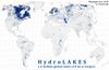 |
| HydroSHEDS | Hydrography | Modeled | Hydrological data and maps based on SHuttle Elevation Derivatives at multiple Scales. | |
| IBCAO | Topography | Modeled | Integrated bathymetric-topographic relief model of the Arctic Ocean; 500-meter cell size |  |
| ICE-5G | Cryosphere | Modeled | Global Grids of Ice Sheet Thickness and Paleotopography for 21,000 - present day |  |
| IEDA data services for observational Geoscience data | Oceanography | Measured | IEDA or Integrated Earth Data Applications provides data services for observational Geoscience data from the Ocean, Earth, and Polar Sciences |  |
| LUSoils v.1 | Land Cover | Modeled | Linking global land use and land cover to hydrologic soil groups from 850 to 2015. |  |
| MERIT DEM | Topography | Measured | The MERIT DEM was developed by removing multiple error components from existing spaceborne DEMs (SRTM3 and AW3D) |  |
| MLD | Oceanography | Measured | Ocean mixed layer depth climatology |  |
| Marine Geophysical Trackline Data | Topography | Measured | NGDC's global database of marine trackline surveys; contains bathymetry, magnetics, gravity and seismic navigation data |  |
| Modeled Suspended Sediment in Global Rivers | River discharge | Modeled | Modeled Global Suspended Sediment Flux |  |
| NCED data repository | Surface properties | Measured | Data from or related to the National Center for Earth-surface Dynamics (NCED) |  |
| NED | Topography | Modeled | U.S. National Elevation Dataset (NED) topographic relief model; 1/9 arc-second (~3 m) cell size to 2 arc-second (~60 m) cell size |  |
| NGDC Coastal Relief Model | Topography | Modeled | Integrated bathymetric-topographic relief models of U.S. coasts; 3 arc-second (~90 m) cell size |  |
| NHD | Hydrography | Measured | The National Hydrography Dataset |  |
| NLCD 1992 | Land Cover | Modeled | National Land Cover Dataset 1992 |  |
| NLCD 2001 | Land Cover | Modeled | National Land Cover Database of 2001 |  |
| NOSHDB | Topography | Measured | Database of U.S. hydrographic surveys conducted by NOAA's National Ocean Service |  |
| NRLP India | River discharge | Modeled | Proposed canals and dams data for the Indian Rivers Interlinking project |  |
| NWIS | River discharge | Measured | National Water Information System (NWIS) |  |
| National Climatic Data Center HDSS Access System | Climate | Measured | Access portal for US weather radar data, satellite data, and additional (US and international) historical weather forecasts and data |  |
| Nearshore Oceanographic Observations at Drew Point, Alaska, Summers 2009 and 2010 | Oceanography | Measured | Nearshore Oceanographic Observations at Drew Point, Alaska, Summers 2009 and 2010 | 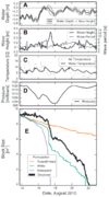 |
| North America 3 arcsec drainage area | Hydrography | Modeled | The drainage area of North America at 3 arc sec resolution, from 7°N, 55°W to 60°N, 142°W |  |
| North American River Width Data Set (NARWidth) | Hydrography | Measured | NARWidth is composed of planform morphometric measurements of North American rivers at approximately mean discharge | 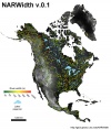 |
| OSCAR | Oceanography | Measured | Ocean Surface Current Analyses - Real time | |
| OneGeology | Substrates | Modeled | Datawarehouse to create a digital geological map of the world |  |
| OpenTopography | Topography | Modeled | Community access to high-resolution, Earth science-oriented, topography data, and related tools and resources. |  |
| PMIP 2 | Climate | Modeled | Output from the second Paleoclimate Modeling Intercomparison Project | |
| PSMSL | Sea level | Measured | Permanent Service for Mean Sea Level (PSMSL) |  |
| Permafrost Temperatures, Alaska | Cryosphere | Measured | U.S. Geological Survey's Borehole Temperature Logs from Arctic Alaska, pre-1989 |  |
| R-ArcticNet | River discharge | Measured | R-ArcticNet (v4.0) - A Regional, Electronic, Hydrographic Data Network For the Arctic Region |  |
| RESSED | Surface properties | Measured | The Reservoir Sedimentation Database |  |
| Realtime Permafrost Alaska | Cryosphere | Measured | U.S. Geological Survey: Real-Time Permafrost and Climate Monitoring Network - Arctic Alaska |  |
| ReefBase | Oceanography | Measured | A global information system for coral reefs |  |
| SRTM | Topography | Measured | Global topography from NASA's 2000 Shuttle Radar Topography Mission (SRTM) |  |
| SSURGO | Surface properties | Measured | SSURGO (Soil Survey Geographic database) refers to digital soils data produced and distributed by the Natural Resources Conservation Service (NRCS) - National Cartography and Geospatial Center (NCGC). |  |
| STATSGO | Surface properties | Measured | The U.S. General Soil Map |  |
| SWBD | Hydrography | Measured | Shuttle Radar Topography Mission Water Body Dataset |  |
| Sage | River discharge | Measured | Global River Discharge Database |  |
| Sea Ice Concentrations NSIDC | Cryosphere | Measured | Sea Ice Concentrations from Nimbus-7 SMMR and DMSP SSM/I Passive Microwave Data |  |
| Sediment Thickness of worlds oceans | Oceanography | Measured | Total Sediment Thickness of the World's Oceans & Marginal Seas |  |
| Southern Alaska Coastal Relief Model | Topography | Modeled | Integrated bathymetric-topographic relief model of Southern Alaska; 24 arc-second cell size | |
| TPXO6.2 | Oceanography | Modeled | Global Inverse Tide Model |  |
| TRMM | Climate | Measured | Tropical Rainfall Measuring Mission | |
| UNPD | Human dimensions | Modeled | United Nations Population Database (1950 - 2050) |  |
| WaveWatch III^TM | Oceanography | Modeled | WAVEWATCH III™ (Tolman 1997, 1999a, 2009) is a third generation wave model developed at NOAA/NCEP in the spirit of the WAM model (WAMDIG 1988, Komen et al. 1994). Simulation results contain waves & swells Hs, direction, period, wind direction, etc. |  |
| World Glacier Inventory | Cryosphere | Measured | Information on glaciers for over 100,000 glaciers through out the world served by the National Snow and Ice Data Center |  |
| World Ocean Atlas 2001 | Oceanography | Measured | World Ocean Atlas 2001 (WOA01) |  |
| World Ocean atlas | Oceanography | Measured | World Ocean Atlas 2009 |  |
| World River Sediment Yields Database | River discharge | Measured | This database contains data on annual sediment yields in worldwide rivers and reservoirs, searchable by river, country and continent. |  |
| World Vector Shoreline | Topography | Measured | World Vector Shoreline |  |
