HPCCprojects:Repeat glacier elevation and velocity maps from multi-view stereophotography
Repeat glacier elevation and velocity maps from multi-view stereophotography
Introduction
Low frequency and high cost restricts the use of satellite and commercial aerial stereophotography for investigating short-term variability in glacier dynamics, the mechanisms by which tidewater and ice sheet outlet glaciers rapidly deliver ice to the oceans. In response, we present a flexible, low-cost, automated approach to producing glacier-wide DEMs and velocity fields requiring only a digital camera and handheld GPS.
Methods
Structure from Motion The method hinges on SfM routines, which harness the depth information implicit in images taken from multiple camera positions ("motion") to automatically reconstruct scene and camera geometry ("structure"). Multi-view stereo software can then harness the solved camera geometry to construct a full resolution "point cloud" in which nearly every image pixel has a corresponding 3D position.
To tie the images together across the wide baseline views needed for a robust solution, SfM relies on state-of-the-art feature detection and matching, like SIFT, which achieves scale-invariance by applying Difference of Gaussians filters of varying widths to the image, and keeping as features the local extrema of the constructed image-scale space. Rather than describe a feature by the surrounding pixel values, SIFT describes features by the direction of local image gradients, which are far more robust to variations in brightness, contrast and viewing direction.
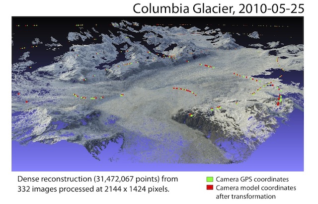
Cameras as Ground Control Since SfM solves for scene and camera geometry simultaneously, surveyed camera positions are sufficient to transform the model to world coordinates. This is extremely useful in mountainous, glaciated terrain where physical access to the scene surface to establish ground control is often impossible or costly.
Velocities With camera geometry and DEMs computed by SfM, velocities can be obtained from repeat models by matching features between best-matching views, then converting the pixel displacements to velocities by intersecting the camera rays with the DEMs.
Results
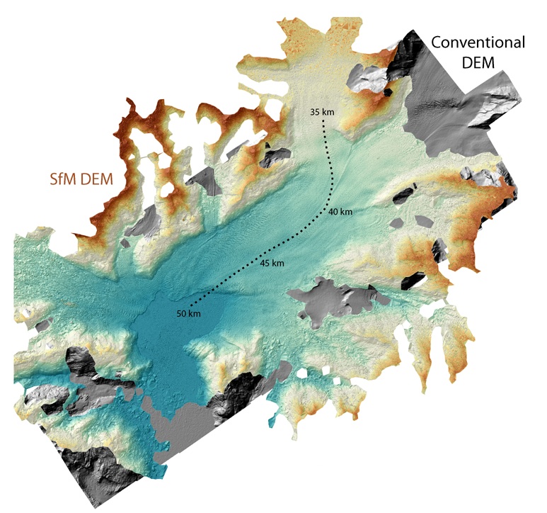
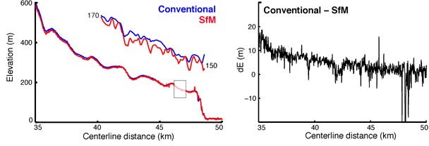
On May 25 and June 2, 2010, mapping missions were flown over Columbia Glacier, a large tidewater glacier in Alaska, at a total cost of USD 18,000, while we photographed the same reaches from a chartered plane, for a total cost of USD 1,200. Results from the first flight are compared below.
Users
- Ethan Welty
(in collaboration with Tad Pfeffer and Shad O'Neel)
Publications and presentations
The Image as Data: Preliminary Results from Columbia Glacier, AK
40th International Arctic Workshop, Winter Park, CO (March 10-12, 2010)
The Image as Data: Glacier Change and Citizen Science
4th Graduate Climate Conference, Seattle, WA (October 15-17, 2010)
Quantifying Evolving (Glacial) Landscapes with Your Camera
American Geophysical Union Fall Meeting, San Francisco, CA (December 13-17, 2010)
