Data:NWIS
NWIS dataset information page
Short Description
| USGS Real-Time Water Data |
Statement: National Water Information System (NWIS)
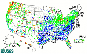
Abstract: The United States Geological Survey (USGS) has collected water-resources data at approximately 1.5 million sites across the United States, Puerto Rico, and Guam.
The types of data collected are varied, but generally fit into the broad categories of surface water and ground water. Surface-water data, such as gage height (stage) and streamflow (discharge), are collected at major rivers, lakes, and reservoirs. Ground-water data, such as water level, are collected at wells and springs.
Water-quality data are available for both surface water and ground water. Examples of water-quality data collected are temperature, specific conductance, pH, nutrients, pesticides, and volatile organic compounds.
This web site serves current and historical data. Data are retrieved by category of data, such as surface water, ground water, or water quality, and by geographic area. Subsequent pages allow further refinement by selecting specific information and by defining the output desired.
Real-time data typically are recorded at 15-60 minute intervals, stored onsite, and then transmitted to USGS offices every 1 to 4 hours, depending on the data relay technique used. Recording and transmission times may be more frequent during critical events. Data from real-time sites are relayed to USGS offices via satellite, telephone, and/or radio and are available for viewing within minutes of arrival. (Note that all real-time data are provisional and subject to revision).
Data format
| Data type: | River discharge |
| Data origin: | Measured |
| Data format: | ASCII |
| Other format: | graphs |
| Data resolution: | Point source data |
| Datum: |
Data Coverage
Spatial data coverage: USA
Temporal data coverage: Time series
Time period covered: variable, 80years till present
Availability
Download data: http://waterdata.usgs.gov/nwis
Data source: http://waterdata.usgs.gov/nwis
References
- [[Key references dataset::U.S. Geological Survey, 2001, National Water Information System (NWISWeb) data available on the World Wide Web, accessed [June 10, 2001], at URL [1].]]

